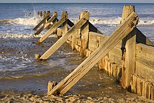
Administratio litoralis
Administratio litoralis est modus inundationis erosionisque defendendarum et rationes quae erosionem ad terras faciendas conservandasque sistunt.[2]


Zonae litorales minus quam quindecim centesimas areae telluris occupant, cum plus quam 45 centesimas omnium hominum sustineant. Paene 1.4 billiones hominum minus quam 100 chiliometra a litore et centum metra a maris aequore habitant, media spissitudine ter altiori quam medium totius telluris.[3] Tribus quartis hominum mundi in zona litorali ante 2025 habitare aestimatis, vita humana litora magnopere afficiet. Terris litoralibus sunt opes naturales magni pretii ad bona et ministeria producenda, ac multa commercii industriaeque negotia sustinent.
Praesidium contra surgentia maris aequora saeculo vicensimo uno est res magni momenti, cum aestus aequoris maris acceleret. Mutationes aequoris maris oras tam laedere, et systemata litoralia magis magisque oriri exspectantur, ut sedimenta litoralia energiá aestús disturbetur.
Litoralis portuum ingeniaria commercio navium coepit, fortasse ante annum 3500 a.C.n. Navalia, moles lapidum in mari structae, et alia portuum opera manu saepe late facta sunt.
Notae
recensere- ↑ Diagramma accommodatum ex Turner 2005.
- ↑ "Coastal Zones".
- ↑ Small et Nicholls 2003.
Bibliographia
recensere- Appeaning Addo, K., M. Walkden, et J. P. Mills. 2008. "Detection, measurement and prediction of shoreline recession in Acccra, Ghana." Journal of Photogrammetry and Remote Sensing 63 (5): 543–58. doi:10.1016/j.isprsjprs.2008.04.001. Textus.
- Allsop, N. W. H. (2002). [(Textus apud Google Books) Breakwaters, Coastal Structures and Coastlines: Proceedings of the International Conference Organized by the Institution of Civil Engineers and Held in London, UK on 26-28 September 2001]. Thomas Telford. pp. 198–. ISBN 978-0-7277-3042-8.
- Anders, F. J, et M. R. Byrnes. 1991. "Accuracy of Shoreline change rates as determined from maps and aerial photographs." Shore and Beach 59 (1): 17–26.
- Bergsma, E. W. J. 2016. "Application of an improved video-based depth inversion technique to a macrotidal sandy beach." Dissertatio, Universitas Plimutensis. Universitas.
- Bergsma, E. W. J.; Conley, D. C.; Davidson, M. A.; O'Hare, T. J. (2016). "Video-based nearshore bathymetry estimation in macro-tidal environments". Marine Geology: 374: 31–41.
- Boak, Elizabeth H.; Turner, Ian L. (2005-07-01). "Shoreline Definition and Detection: A Review". Journal of Coastal Research: 214: 688–703
- Camfield, F. E.; Morang, A. (1996). "Defining and interpreting shoreline change". Ocean and Coastal Management: 32 (3): 129–151.
- Castelle, B.; Marieu, V.; Bujana, S.; Splinter, K. D.; Robinet, A.; Snchal, N.; Ferreira, S. (2015). "Impact of the winter 20132014 series of severe western europe storms on a double-barred sandy coast: Beach and dune erosion and megacusp embayments". Geomorphology: 238: 135–148.
- Crowell, M.; Leatherman, S. P.; Buckley, M. K. (1991). "Historical Shoreline Change: Error Analysis and Mapping Accuracy". Journal of Coastal Research: 7 (30: 5–13.
- Graham, D.; Sault, M.; Bailey, J. (2003). "National Ocean Service Shoreline – Past, Present and Future". Journal of Coastal Research.
- Holman, Rob; Plant, Nathaniel; Holland, Todd (2013-05-01). "cBathy: A robust algorithm for estimating nearshore bathymetry". Journal of Geophysical Research: Oceans: 118 (5): 2595–09.
- Leatherman, S. P. (2003). "Shoreline Change Mapping and Management Along the U.S. East Coast". Journal of Coastal Research: 38: 5–13.
- Maiti, S.; Bhattacharya, A. K. (2009). "Shoreline change analysis & its application to prediction: A remote sensing and statistics based approach". Marine Geology: 257: 11–23.
- Masselink, Gerd; Scott, Tim; Poate, Tim; Russell, Paul; Davidson, Mark; Conley, Daniel (2016-03-15). "The extreme 2013/2014 winter storms: hydrodynamic forcing and coastal response along the southwest coast of England". Earth Surface Processes and Landforms: 41 (3): 378–91.
- Moore, J. (2000). "Shoreline Mapping Techniques". Journal of Coastal Research: 16 (1): 111–24
- Morton, R. A. (1991). "Accurate shoreline mapping: past, present, and future". Coastal Sediments 1.
- Pajak, M.J.; Leatherman, S. P. (2002). "The High Water Line as Shoreline Indicator". Journal of Coastal Research.
- Plant, N. G.; Holland, K. T.; Haller, M. C. (2008-09-01). "Ocean Wavenumber Estimation From Wave-Resolving Time Series Imagery". IEEE Transactions on Geoscience and Remote Sensing: 46 (9): 2644–58.
- The Rock Manual: The Use of Rock in Hydraulic Engineering. CIRIA. 2007. ISBN 978-0-86017-683-1
- Small, Christopher; Nicholls, Robert J. (2003). "A Global Analysis of Human Settlement in Coastal Zones". Journal of Coastal Research: 19 (3): 584–599.
- Smit, M. W. J.; Aarninkhof, S. G. J.; Wijnberg, K. M.; Gonzalez, M. M; Kingstong, K. S.; Ruessink, B. G.; Holman, R. A.; Segle, E. et al (2007). "The role of video imagery in predicting daily to monthly coastal evolution". Coastal Engineering: 54 (54): 539–553.
- Turner, I. L.; Leatherman, S. P. (1997). "Beach Dewatering as a 'Soft' Engineering Solution to Coastal Erosion: A History and Critical Review". Journal of Coastal Research.
- Turner, Ian L.; Aarninkhof, S. G. J.; Dronkers, T. D. T.; McGrath, J. (2004-07-01). "CZM Applications of Argus Coastal Imaging at the Gold Coast, Australia". Journal of Coastal Research: 20: 739–52.
- Van Koningsveld, M., M. Davidson, D. Huntly, R. Medina, S. Aarninkhof, J. A. Jimenez, J. Ridgewell, et A. de Kruif. 2007. "A critical review of the CoastView project: Recent and future developments in coastal management video systems." Coastal Engineering 54: 567–76. doi:10.1016/j.coastaleng.2007.01.006. Textus.
- Woodroffe, C. D. 2002. Coasts: Form, Process and Evolution. Cantabrigiae: Cambridge University Press. ISBN 978-0-521-01183-9.
Nexus interni
Nexus externi
recensere| Vicimedia Communia plura habent quae ad administrationem litoralem spectant. |
- Wiki litorale.
- "Coastal Defenses in the Netherlands." Deltaworks Online.
- "Coastal Zone Management Policy and Politics Class."
- Encora Coastal Wiki/
- "Social and Economic Benefits of Coastal Resource Management." NOAA Socioeconomics.
- Coastal Resources Center, University of Rhode Island.
- Pelliculae
- Pellicula educationales liberae de rationibus litoralibus et administratione zonarum.
- Formula:Youtube
- Imagines