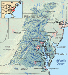
Sinus Chesapeacus
Sinus Chesapeacus[1] est maximum aestuarium in Civitatibus Foederatis,[2] apud Oceanum Atlanticum situs, a Terra Mariae et Virginia circumscriptus.


Nexus interni
Notae
recensere- ↑ Iohannes Iacobus Hofmannus, Lexicon universale (1698) ~, Sectio Nomenclator p.21
- ↑ Leslie Kaufman (28 Dec 2010). "More Blue Crabs, but Chesapeake Bay Is Still at Risk, Report Says". The New York Times
Bibliographia
recensere- Cleaves, E. T., et al. 2006. Quaternary geologic map of the Chesapeake Bay 4º x 6º quadrangle, United States. Miscellaneous Investigations Series; Map I-1420 (NJ-18). Reston Virginiae: U.S. Department of the Interior, U.S. Geological Survey.
- Phillips, S. W., ed. 2007. Synthesis of U.S. Geological Survey science for the Chesapeake Bay ecosystem and implications for environmental management. U.S. Geological Survey Circular 1316. Reston, Virginiae: U.S. Department of the Interior, U.S. Geological Survey.
- Thomas, William G., III. 2004. "The Chesapeake Bay." Southern Spaces, 16 April, http://southernspaces.org/2004/chesapeake-bay.
- William W. Warner. 1976. Beautiful Swimmers. De histora, oecologia, et anthropologia Sinus Chesapeaci.