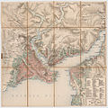
Fasciculus:12 - Konstantinopel; Scheda-Karte europ Türkei.jpg

Sua resolutio (6 019 × 6 018 elementa imaginalia, magnitudo fasciculi: 45.85 megaocteti, typus MIME: image/jpeg)

Hic fasciculus apud Vicimedia Communia iacet; in aliis inceptis adhiberi potest. Contenta paginae descriptionis fasciculi subter monstrantur.

Summarium

Descriptio
Deutsch: Konstantinopel, Pera, Skutari,Goldenes Horn, südlicher Bosporus, aus der Generalkarte der europäischen Türkei und Griechenlands
Datum 1860 - 1870
date QS:P,+1850-00-00T00:00:00Z/7,P1319,+1860-00-00T00:00:00Z/9,P1326,+1870-00-00T00:00:00Z/9
Fons Militärgeographisches Institut der österreichisch-ungarischen Monarchie aus den Jahren 1860-70
Auctor Aufnahmeteam des Militärgeographischen Institutes der österreichisch-ungarischen Monarchie unter der Leitung von Josef Scheda um 1860-70

Potestas usoris

Public domain

This work is in the public domain in its country of origin and other countries and areas where the copyright term is the author's life plus 100 years or fewer.


You must also include a United States public domain tag to indicate why this work is in the public domain in the United States.
This file has been identified as being free of known restrictions under copyright law, including all related and neighboring rights.

Public domain
Public domain
This media file is in the public domain in the United States. This applies to U.S. works where the copyright has expired, often because its first publication occurred prior to January 1, 1929, and if not then due to lack of notice or renewal. See this page for further explanation.

United States
United States
This image might not be in the public domain outside of the United States; this especially applies in the countries and areas that do not apply the rule of the shorter term for US works, such as Canada, Mainland China (not Hong Kong or Macao), Germany, Mexico, and Switzerland. The creator and year of publication are essential information and must be provided. See Wikipedia:Public domain and Wikipedia:Copyrights for more details.

Captions

Add a one-line explanation of what this file represents
1860–70 German map of Ottoman-era Istanbul, showing the Golden Horn (Sector B2) and its source rivers, Alibeyköy and Kağıthane

Items portrayed in this file

depicts Anglica

media type Anglica

image/jpeg

checksum Anglica

0723ee2c3dcb92eebcec66e7f8306d3afe3c5bad

data size Anglica

48 072 871 byte

6 018 Pixel

6 019 Pixel

Historia fasciculi

Presso die vel tempore fasciculum videbis, sicut tunc temporis apparuit.

Dies/TempusMinutioDimensionesUsorSententia
recentissima20:56, 19 Maii 2012Minutum speculum redactionis 20:56, 19 Maii 2012 factae6 019 × 6 018 (45.85 megaocteti)Josef Moser

Usus fasciculi per inceptus Vicimediorum

Metadata