Fasciculus:Zambezi river basin-fr.svg

Size of this PNG preview of this SVG file: 800 × 511 elementa imaginalia. Aliae mensurae: 320 × 204 elementa imaginalia | 640 × 409 elementa imaginalia | 1 024 × 654 elementa imaginalia | 1 280 × 818 elementa imaginalia | 2 560 × 1 636 elementa imaginalia | 2 931 × 1 873 elementa imaginalia.
Sua resolutio (fasciculus SVG, nominale 2 931 × 1 873 elementa imaginalia, magnitudo fasciculi: 2.12 megaocteti)
Summarium
| Descriptio | |||
| Datum | |||
| Fons |
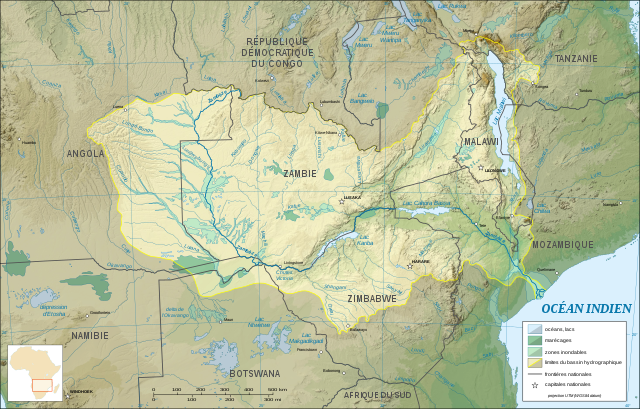
Opus proprium (Original text: Own work ; Topographic background map : NASA Shuttle Radar Topography Mission (SRTM30 v.2) (public domain) edited with MicroDEM and dlgv32 Pro / Global Mapper ; UTM projection ; WGS84 datum ; References for the additional data : Demis World Map data (see the approval e-mail and the Demis forum) and UNESCO map ; Locator map : File:Africa map blank.svg (modified) created by myself.) |
||
| Auctor | Eric Gaba (Sting - fr:Sting) | ||
| Permissio (Reusing this file) |
|
||
| Other versions |
Derivative works of this file: |
||
| SVG genesis |

Potestas usoris
I, Sting, the copyright holder of this work, hereby publishes it under the following licenses:

|
Licet hoc documentum exscribere vel distribuere vel demutare sub GNU Liberarum Litterarum Licentiae conditionibus in editione 1.2 aut in ulla editione recentiori a Fundatione Liberarum Programmationis Partium publicata; praeterquam Sectiones Immutabiles et Verba Involucra Adversa et Aversa. Licentiae exemplar praesto est in sectione intitulata GNU Free Documentation License. |
| This file is licensed under the Creative Commons Attribution-Share Alike 3.0 Unported license. | ||
| Attributio: I, Sting | ||
| ||
| This licensing tag was added to this file as part of the GFDL licensing update. |
This file is licensed under the Creative Commons Attribution-Share Alike 2.5 Generic, 2.0 Generic and 1.0 Generic license.
Attributio: I, Sting
- Tibi licet:
- communicare – copiare, distribuere et committere hoc opus
- to remix – to adapt the work
- His condicionibus:
- attributio – You must give appropriate credit, provide a link to the license, and indicate if changes were made. You may do so in any reasonable manner, but not in any way that suggests the licensor endorses you or your use.
- aequa parte – If you remix, transform, or build upon the material, you must distribute your contributions under the same or compatible license as the original.
Tibi typum permissionis ligere licet.
Historia fasciculi
Presso die vel tempore fasciculum videbis, sicut tunc temporis apparuit.
| Dies/Tempus | Minutio | Dimensiones | Usor | Sententia | |
|---|---|---|---|---|---|
| recentissima | 19:09, 19 Ianuarii 2008 | | 2 931 × 1 873 (2.12 megaocteti) | Sting | Trying other solution (part 2) |
| 19:03, 19 Ianuarii 2008 |  | 2 440 × 1 560 (832 chiliocteti) | Sting | Trying other solution (part 1) | |
| 13:04, 31 Iulii 2007 |  | 2 931 × 1 873 (2.12 megaocteti) | Sting | Again... | |
| 12:53, 31 Iulii 2007 |  | 2 931 × 1 873 (2.3 megaocteti) | Sting | Again | |
| 12:46, 31 Iulii 2007 |  | 2 931 × 1 873 (2.31 megaocteti) | Sting | Again | |
| 12:35, 31 Iulii 2007 |  | 2 931 × 1 873 (2.31 megaocteti) | Sting | Again | |
| 12:16, 31 Iulii 2007 |  | 2 931 × 1 873 (2.31 megaocteti) | Sting | Display problem with the raster background map | |
| 02:30, 31 Iulii 2007 |  | 2 931 × 1 873 (2.28 megaocteti) | Sting | {{Information |Description=Map in French of the Zambezi river hydrographic basin, Africa |Source=Own work ;<br/>Topographic background map : [http://www2.jpl.nasa.gov/srtm NASA Shuttle Radar Topography Mission] (SRTM30 v.2) (public domain) edited with [ht |
Nexus ad fasciculum
Nullae paginae hoc fasciculo utuntur.
Usus fasciculi per inceptus Vicimediorum
Quae incepta Vici fasciculo utuntur:
- Usus in ar.wikipedia.org
- Usus in es.wikipedia.org
- Usus in eu.wikipedia.org
- Usus in fr.wikipedia.org
- Usus in gl.wikipedia.org
- Usus in ky.wikipedia.org
- Usus in ln.wikipedia.org
- Usus in uk.wikipedia.org