Fasciculus:Sabratha excavation Panorama April 2004.jpg

Mensura huius perspectionis: 800 × 102 elementa imaginalia. Aliae mensurae: 320 × 41 elementa imaginalia | 640 × 81 elementa imaginalia | 1 024 × 130 elementa imaginalia | 1 280 × 163 elementa imaginalia | 15 483 × 1 971 elementa imaginalia.
Sua resolutio (15 483 × 1 971 elementa imaginalia, magnitudo fasciculi: 3.03 megaocteti, typus MIME: image/jpeg)
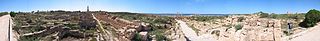
- Description: Panorama view on the excavation of Sabratha, Libya.
- Source: Taken myself in 14 portrait photographs and stiched them together using the software supplyied with the Camera. I had to remove some people from the picture, because I did not ask them about publishing their photograph. This was done with the "clone"-Tool of "The GIMP". However, these were only minimal modifications, so you get no "fake" impression when looking at the image.
- Photographer: Robert Bamler

|
Licet hoc documentum exscribere vel distribuere vel demutare sub GNU Liberarum Litterarum Licentiae conditionibus in editione 1.2 aut in ulla editione recentiori a Fundatione Liberarum Programmationis Partium publicata; praeterquam Sectiones Immutabiles et Verba Involucra Adversa et Aversa. Licentiae exemplar praesto est in sectione intitulata GNU Free Documentation License. |
| This file is licensed under the Creative Commons Attribution-Share Alike 3.0 Unported license. | ||
| ||
| This licensing tag was added to this file as part of the GFDL licensing update. |
| Camera location | | View this and other nearby images on: OpenStreetMap |
|---|
Historia fasciculi
Presso die vel tempore fasciculum videbis, sicut tunc temporis apparuit.
| Dies/Tempus | Minutio | Dimensiones | Usor | Sententia | |
|---|---|---|---|---|---|
| recentissima | 22:36, 24 Iulii 2005 | 15 483 × 1 971 (3.03 megaocteti) | Robamler | *Description: Panorama view on the excavation of Leptis Magna, Libya. *Source: Taken myself in 14 portrait photographs and stiched them together using the software supplyied with the Camera. I had to remove some people from the picture, because I did not |
Nexus ad fasciculum
Ad hunc fasciculum nectit:
Usus fasciculi per inceptus Vicimediorum
Quae incepta Vici fasciculo utuntur:
- Usus in ar.wikipedia.org
- Usus in ast.wikipedia.org
- Usus in ba.wikipedia.org
- Usus in be.wikipedia.org
- Usus in ca.wikipedia.org
- Usus in de.wikipedia.org
- Usus in en.wikipedia.org
- Usus in eo.wikipedia.org
- Usus in es.wikipedia.org
- Usus in fr.wikipedia.org
- Usus in gl.wikipedia.org
- Usus in he.wikipedia.org
- Usus in hr.wikipedia.org
- Usus in hy.wikipedia.org
- Usus in ja.wikipedia.org
- Usus in ka.wikipedia.org
- Usus in mk.wikipedia.org
- Usus in mt.wikipedia.org
- Usus in pl.wikipedia.org
- Usus in pt.wikipedia.org
- Usus in ru.wikipedia.org
- Usus in sh.wikipedia.org
- Usus in uk.wikipedia.org