Fasciculus:NorthAmericaDivides.gif
Nulla maior resolutio exstat.
NorthAmericaDivides.gif (540 × 481 elementa imaginalia, magnitudo fasciculi: 56 chiliocteti, typus MIME: image/gif)

|
This geology image could be re-created using vector graphics as an SVG file. This has several advantages; see Commons:Media for cleanup for more information. If an SVG form of this image is available, please upload it and afterwards replace this template with
{{vector version available|new image name}}.
It is recommended to name the SVG file “NorthAmericaDivides.svg”—then the template Vector version available (or Vva) does not need the new image name parameter. |
This map was obtained from an edition of the National Atlas of the United States. Like almost all works of the U.S. federal government, works from the National Atlas are in the public domain in the United States.
Online access: NationalAtlas.gov | 1970 print edition: Library of Congress, Perry-Castañeda Library
|
Historia fasciculi
Presso die vel tempore fasciculum videbis, sicut tunc temporis apparuit.
| Dies/Tempus | Minutio | Dimensiones | Usor | Sententia | |
|---|---|---|---|---|---|
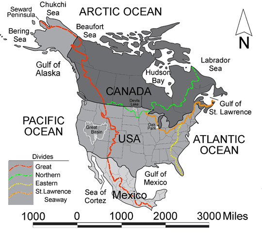
| recentissima | 22:27, 20 Februarii 2005 | | 540 × 481 (56 chiliocteti) | Don Braffitt | North America Continental Divides |
Nexus ad fasciculum
Nullae paginae hoc fasciculo utuntur.
Usus fasciculi per inceptus Vicimediorum
Quae incepta Vici fasciculo utuntur:
- Usus in bg.wikipedia.org
- Usus in ca.wikipedia.org
- Usus in de.wikipedia.org
- Usus in de.wiktionary.org
- Usus in en.wikibooks.org
- Usus in en.wiktionary.org
- Usus in es.wikipedia.org
- Usus in fi.wikipedia.org
- Usus in fr.wikipedia.org
- Usus in he.wikipedia.org
- Usus in it.wikipedia.org
- Usus in nl.wikipedia.org
- Usus in pl.wikipedia.org
- Usus in pt.wikipedia.org
- Usus in sr.wikinews.org
- САД и Канада захваћене таласом великих врућина
- Шаблон:Северна Америка
- Препешачио Нијагарине водопаде ходајући по жици
- У снежној олуји у Северној Америци 15 мртвих
- Нови талас рекордне хладноће у Северној Америци
- Снег, лед и велике хладноће у САД
- У САД и даље велике хладноће и невреме
- У САД најмање 21 преминулих због велике хладноће
- Попушта ледени талас у САД и Канади
- Поново невреме у САД
- Нова снежна олуја погодила исток САД
- Нова снежна олуја у Канади и САД
- Порекло данашњих Индијанаца од пре 12.600 година
- Залеђена Велика језера у Мичигену
- Вирус Зика се рапидно шири
- Usus in uk.wikipedia.org