Fasciculus:Map of 1746. Longitudines numeratae a Primo Meridiano per Insula Ferri.jpg
Nulla maior resolutio exstat.
Map_of_1746._Longitudines_numeratae_a_Primo_Meridiano_per_Insula_Ferri.jpg (800 × 300 elementa imaginalia, magnitudo fasciculi: 104 chiliocteti, typus MIME: image/jpeg)
Summarium
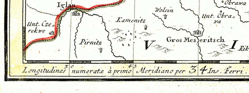
Larger towns:
On the lowest edge of the map - Latin message:
- Longitudines numeratæ à primo Meridiano per Insula Ferri - meaning the prime meridian for this map is El Hierro Island (known as Ferro as well)
Polski: Fragment mapy Górnego Śląska z roku 1746.
Większe miejscowości:
Na samym dole przy krawędzi mapy łacińska informacja:
- Longitudines numeratæ à primo Meridiano per Insula Ferri - oznaczająca, że południkiem odniesienia dla tej mapy jest południk wyspy El Hierro (znanej też jako Ferro)
Potestas usoris
|
This is a faithful photographic reproduction of a two-dimensional, public domain work of art. The work of art itself is in the public domain for the following reason:
The official position taken by the Wikimedia Foundation is that "faithful reproductions of two-dimensional public domain works of art are public domain". This photographic reproduction is therefore also considered to be in the public domain in the United States. In other jurisdictions, re-use of this content may be restricted; see Reuse of PD-Art photographs for details. {{PD-Art}} template without license parameter: please specify why the underlying work is public domain in both the source country and the United States
(Usage: {{PD-Art|1=|deathyear=''year of author's death''|country=''source country''}}, where parameter 1= can be PD-old-auto, PD-old-auto-expired, PD-old-auto-1996, PD-old-100 or similar. See Commons:Multi-license copyright tags for more information.) | ||||
Historia fasciculi
Presso die vel tempore fasciculum videbis, sicut tunc temporis apparuit.
| Dies/Tempus | Minutio | Dimensiones | Usor | Sententia | |
|---|---|---|---|---|---|
| recentissima | 20:21, 4 Decembris 2005 | 800 × 300 (104 chiliocteti) | Julo | {{en}} Detail of the map of Silesia drawn in 1746. *Iglau = moravian city en:JihlavaJihlava *Gros Meseritsch = moravian town Velké Meziříčí On the lowest edge of the |
Nexus ad fasciculum
Ad hunc fasciculum nectit:
Usus fasciculi per inceptus Vicimediorum
Quae incepta Vici fasciculo utuntur:
- Usus in az.wikipedia.org
- Usus in en.wikipedia.org
- Usus in eo.wikipedia.org
- Usus in es.wikipedia.org
- Usus in fr.wikipedia.org
- Usus in hu.wikipedia.org
- Usus in it.wikipedia.org
- Usus in ja.wikipedia.org
- Usus in nl.wikipedia.org
- Usus in pl.wikipedia.org
- Usus in sl.wikipedia.org
- Usus in sr.wikipedia.org