Fasciculus:MH -map A.png

Mensura huius perspectionis: 740 × 600 elementa imaginalia. Aliae mensurae: 296 × 240 elementa imaginalia | 592 × 480 elementa imaginalia | 950 × 770 elementa imaginalia.
Sua resolutio (950 × 770 elementa imaginalia, magnitudo fasciculi: 20 chiliocteti, typus MIME: image/png)

|
This locator map image could be re-created using vector graphics as an SVG file. This has several advantages; see Commons:Media for cleanup for more information. If an SVG form of this image is available, please upload it and afterwards replace this template with
{{vector version available|new image name}}.
It is recommended to name the SVG file “MH -map A.svg”—then the template Vector version available (or Vva) does not need the new image name parameter. |
Summarium
| Descriptio |
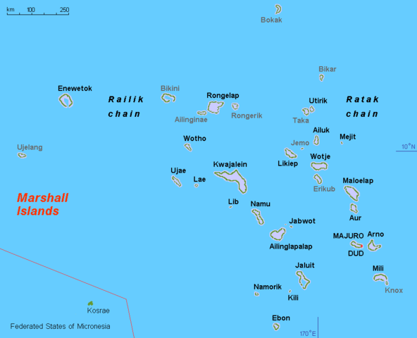
English: Map (rough) Marshall islands, own work composed from various mapreferences |
| Datum | |
| Fons | Opus proprium |
| Auctor | Hobe / Holger Behr |
| Other versions |
Derivative works of this file: Operation K Map.jpg
|
Potestas usoris
| I, the copyright holder of this work, release this work into the public domain. This applies worldwide. In some countries this may not be legally possible; if so: I grant anyone the right to use this work for any purpose, without any conditions, unless such conditions are required by law. |
Historia fasciculi
Presso die vel tempore fasciculum videbis, sicut tunc temporis apparuit.
| Dies/Tempus | Minutio | Dimensiones | Usor | Sententia | |
|---|---|---|---|---|---|
| recentissima | 13:44, 11 Novembris 2010 | | 950 × 770 (20 chiliocteti) | Hobe | minor design change, restored origional uploader |
| 04:03, 17 Septembris 2010 |  | 950 × 775 (31 chiliocteti) | Lasunncty | uninhabited islands/atolls in grey | |
| 17:59, 19 Martii 2008 |  | 950 × 775 (20 chiliocteti) | Hobe | map (rough) Marshall islands, larger letters Source: self-made, composed from various mapreferences Date 2008-03-13 Author Hobe Category:Maps of the Marshall Islands | |
| 18:27, 16 Martii 2008 |  | 950 × 650 (17 chiliocteti) | Hobe | {{Information |Description=map (rough) Marshall islands |Source=self-made, composed from various mapreferences |Date=2008-03-03 |Author= Hobe |Permission= |other_versions= Category:Maps of the Marshall Islands }} Source |
Nexus ad fasciculum
Ad hunc fasciculum nectit:
Usus fasciculi per inceptus Vicimediorum
Quae incepta Vici fasciculo utuntur:
- Usus in af.wikipedia.org
- Usus in ami.wikipedia.org
- Usus in ar.wikipedia.org
- Usus in ast.wikipedia.org
- Usus in ba.wikipedia.org
- Usus in br.wikipedia.org
- Usus in ca.wikipedia.org
- Usus in da.wikipedia.org
- Usus in el.wikipedia.org
- Usus in en.wikipedia.org
- Usus in en.wiktionary.org
- Usus in es.wikipedia.org
- Usus in eu.wikipedia.org
- Usus in fa.wikipedia.org
- Usus in fi.wikipedia.org
- Usus in fr.wikipedia.org
- Usus in gl.wikipedia.org
View more global usage of this file.