Fasciculus:East Francia 843.svg

Size of this PNG preview of this SVG file: 500 × 380 elementa imaginalia. Aliae mensurae: 316 × 240 elementa imaginalia | 632 × 480 elementa imaginalia | 1 011 × 768 elementa imaginalia | 1 280 × 973 elementa imaginalia | 2 560 × 1 946 elementa imaginalia.
Sua resolutio (fasciculus SVG, nominale 500 × 380 elementa imaginalia, magnitudo fasciculi: 933 chiliocteti)
Summarium
This W3C-unspecified vector image was created with Inkscape .


.svg)
.svg)
.svg)
.svg)
.svg)


.svg)
.svg)
.svg)


.png)
.png)


.svg)


.svg)

.svg)


.svg)
.svg)
.svg)
.svg)


.svg)
.png)


.svg)


.svg)
.svg)


.svg)


.svg)


.svg)
.svg)
.svg)
.svg)
.svg)
.svg)
.svg)
_cropped.svg)
.svg)
.svg)
.svg)
.svg)
.svg)
.svg)
.svg)
.svg)
.svg)
.svg)
.svg)
.svg)
.svg)
.svg)
.svg)
.svg)
.svg)
.svg)
.svg)
.svg)
.svg)
.svg)
.svg)
.svg)
.svg)
.svg)
.svg)
.svg)
.svg)
.svg)
.svg)
.svg)
.svg)
.svg)
.svg)
.svg)
.svg)
.svg)
.svg)
.svg)
.svg)
.svg)
.svg)
.svg)
.svg)
Potestas usoris
This file is licensed under the Creative Commons Attribution-Share Alike 4.0 International license.
- Tibi licet:
- communicare – copiare, distribuere et committere hoc opus
- to remix – to adapt the work
- His condicionibus:
- attributio – You must give appropriate credit, provide a link to the license, and indicate if changes were made. You may do so in any reasonable manner, but not in any way that suggests the licensor endorses you or your use.
- aequa parte – If you remix, transform, or build upon the material, you must distribute your contributions under the same or compatible license as the original.
Historia fasciculi
Presso die vel tempore fasciculum videbis, sicut tunc temporis apparuit.
| Dies/Tempus | Minutio | Dimensiones | Usor | Sententia | |
|---|---|---|---|---|---|
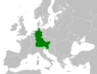
| recentissima | 10:06, 6 Augusti 2021 | | 500 × 380 (933 chiliocteti) | E-960 | Vassal states (aka Slavic tribes) did not make up the territory of East Francia, also in most cases it only represented an alliance with East Francia rather than subjugation. |
| 02:25, 26 Maii 2016 |  | 500 × 380 (932 chiliocteti) | Alphathon | == {{int:filedesc}} == {{Inkscape}} {{Information |Description={{en|A map of East Francia within Europe circa 843 CE, following the treaty of Verdun.}} |Source= {{Derived from|Blank_map_of_Europe.svg|display=50}} '''Data sour... |
Nexus ad fasciculum
Ad hunc fasciculum nectit:
Usus fasciculi per inceptus Vicimediorum
Quae incepta Vici fasciculo utuntur:
- Usus in azb.wikipedia.org
- Usus in bg.wikipedia.org
- Usus in ceb.wikipedia.org
- Usus in cs.wikipedia.org
- Usus in da.wikipedia.org
- Usus in el.wikipedia.org
- Usus in en.wikipedia.org
- Usus in es.wikipedia.org
- Usus in et.wikipedia.org
- Usus in fa.wikipedia.org
- Usus in fi.wikipedia.org
- Usus in fr.wikipedia.org
- Usus in fy.wikipedia.org
- Usus in he.wikipedia.org
- Usus in hr.wikipedia.org
- Usus in hy.wikipedia.org
- Usus in id.wikipedia.org
- Usus in it.wikipedia.org
- Usus in ja.wikipedia.org
- Usus in ko.wikipedia.org
- Usus in ku.wikipedia.org
- Usus in lv.wikipedia.org
- Usus in mk.wikipedia.org
- Usus in pl.wikipedia.org
- Usus in pt.wikipedia.org
- Usus in ru.wikipedia.org
- Usus in sl.wikipedia.org
- Usus in sr.wikipedia.org
- Usus in th.wikipedia.org
- Usus in tr.wikipedia.org
- Usus in uk.wikipedia.org
- Usus in vi.wikipedia.org
- Usus in zh.wikipedia.org
View more global usage of this file.