Fasciculus:Byzantine Constantinople-en.svg

Size of this PNG preview of this SVG file: 662 × 600 elementa imaginalia. Aliae mensurae: 265 × 240 elementa imaginalia | 530 × 480 elementa imaginalia | 848 × 768 elementa imaginalia | 1 130 × 1 024 elementa imaginalia | 2 261 × 2 048 elementa imaginalia | 2 085 × 1 889 elementa imaginalia.
Sua resolutio (fasciculus SVG, nominale 2 085 × 1 889 elementa imaginalia, magnitudo fasciculi: 3.69 megaocteti)
Summarium
| Descriptio |
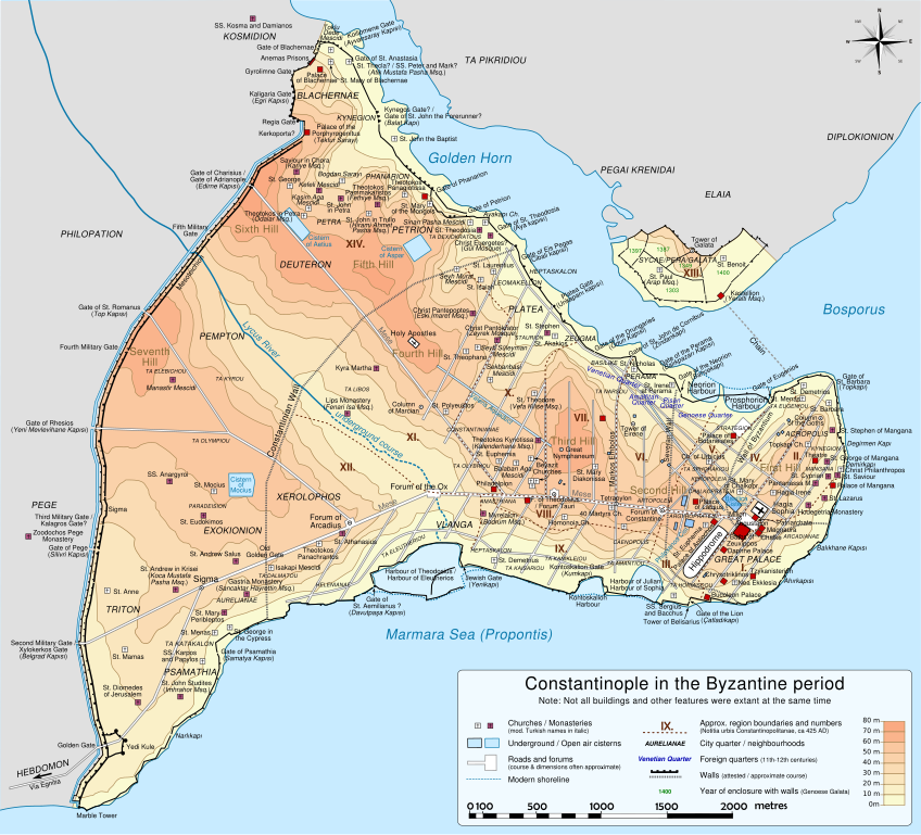
Deutsch: Topografische Karte Konstantinopels während des byzantinischen Zeitraums. Quelle: R. Janin, Constantinople Byzantine. Developpement urbain et repertoire topographique. Straßennetz und andere Einzelheiten basiert auf Dumbarton Oaks Papers 54. Kirchen, insb. nicht identifizierte und ausgegrabene Bauten sind aus dem The Byzantine Churches of Istanbul entnommen. Andere herausgegebenen Quellen wurden behilfsmäßig gebraucht. English: Topographical map of Constantinople during the Byzantine period. Main map source: R. Janin, Constantinople Byzantine. Developpement urbain et repertoire topographique. Road network and some other details based on Dumbarton Oaks Papers 54; data on many churches, especially unidentified ones, taken from the University of New York's The Byzantine Churches of Istanbul project. Other published maps and accounts of the city have been used for corroboration. Français : Carte en anglais de Constantinople à l'époque Byzantine. Source principale : R. Janin, Constantinople Byzantine. Développement urbain et répertoire topographique. Le réseau routier et d'autres détails proviennent de Dumbarton Oaks Papers 54. Les données concernant de nombreuses églises, en particulier celles non identifiées, viennent de l'université de New York : le projet The Byzantine Churches of Istanbul (Les églises byzantines d'Istanbul). D'autres cartes encore ont été utilisées pour recouper et vérifier les informations. Türkçe: tr:Konstantinopolis'in Bizans dönemindeki topografik haritası. Ana haritanın kaynağı: R. Janin, Constantinople Byzantine. Developpement urbain et repertoire topographique. Yol haritası ve bazı diğer ayrıntıların kaynağı: Dumbarton Oaks Papers 54; kiliseler, özellikle kimliği belirlenmemiş olanlar hakkında veriler, New York University'nin İstanbul'un Bizans Kiliseleri projesinden elde edilmiştir. Şehir hakkında yayımlanmış diğer harita ve metinler bu bilgileri doğrulamak için kullanılmıştır. Ελληνικά: Τοπογραφικός χάρτης Κωνσταντινουπόλεως κατά τη Βυζαντινή περίοδο. Βασική πηγή χάρτη: R. Janin, Constantinople Byzantine. Developpement urbain et repertoire topographique. Το οδικό δίκτυο και διάφορες άλλες λεπτομέρειες με βάση το Dumbarton Oaks Papers 54. Πληροφορίες για τις εκκλησίες, ιδιαίτερα τις μη ταυτοποιημένες, από την ιστοσελίδα The Byzantine Churches of Istanbul του Πανεπιστημίου της Νέας Υόρκης. Български: Топографска карта на Константинопол (Цариград) през византийския период. Източник: R. Janin, Constantinople Byzantine. Developpement urbain et repertoire topographique. Пътната мрежа и някои други детайли се основават на Dumbarton Oaks Papers 54 и други публикувани източници. |
||
| Datum | |||
| Fons | Opus proprium | ||
| Auctor | Cplakidas | ||
| Other versions |
[] Full mapsSVG:
PNG:
Numeric versions
Regions
Roads
Derivative works of this file: | ||
| SVG | W3C-validity not checked.
|


| Camera location | | View this and other nearby images on: OpenStreetMap |
|---|
Potestas usoris
I, the copyright holder of this work, hereby publish it under the following licenses:
This file is licensed under the Creative Commons Attribution-Share Alike 3.0 Unported license.
- Tibi licet:
- communicare – copiare, distribuere et committere hoc opus
- to remix – to adapt the work
- His condicionibus:
- attributio – You must give appropriate credit, provide a link to the license, and indicate if changes were made. You may do so in any reasonable manner, but not in any way that suggests the licensor endorses you or your use.
- aequa parte – If you remix, transform, or build upon the material, you must distribute your contributions under the same or compatible license as the original.

|
Licet hoc documentum exscribere vel distribuere vel demutare sub GNU Liberarum Litterarum Licentiae conditionibus in editione 1.2 aut in ulla editione recentiori a Fundatione Liberarum Programmationis Partium publicata; praeterquam Sectiones Immutabiles et Verba Involucra Adversa et Aversa. Licentiae exemplar praesto est in sectione intitulata GNU Free Documentation License. |
Tibi typum permissionis ligere licet.
Historia fasciculi
Presso die vel tempore fasciculum videbis, sicut tunc temporis apparuit.
| Dies/Tempus | Minutio | Dimensiones | Usor | Sententia | |
|---|---|---|---|---|---|
| recentissima | 20:48, 13 Martii 2012 | | 2 085 × 1 889 (3.69 megaocteti) | Sémhur | New version, with cleaned code and a new layer "editable text, hidden" made with font "Nimbus Sans L", containing all the texts, and other layers with text as path (not editables, but visibles). |
| 13:13, 15 Decembris 2009 |  | 2 050 × 1 850 (8.13 megaocteti) | Cplakidas | larger & improved version, various corrections, Galata included | |
| 22:53, 8 Ianuarii 2009 |  | 1 600 × 1 500 (5.79 megaocteti) | Cplakidas | {{Information |Description= |Source= |Date= |Author= |Permission= |other_versions= }} | |
| 23:26, 14 Novembris 2008 |  | 1 600 × 1 500 (5.29 megaocteti) | Cplakidas | attempt to get text right | |
| 11:38, 28 Octobris 2008 |  | 1 600 × 1 500 (5.31 megaocteti) | Cplakidas | final version (hopefully): added remaining churches & corrected locations, minor tweaks at places | |
| 19:10, 27 Octobris 2008 |  | 1 600 × 1 500 (4.81 megaocteti) | Cplakidas | completed outer land wall, fixed Golden Gate, fixed sea walls & added known gates, minor location corrections & additions | |
| 17:46, 25 Octobris 2008 |  | 1 600 × 1 500 (2.74 megaocteti) | Cplakidas | text into paths, enlarged map for improved readability | |
| 00:59, 24 Octobris 2008 |  | 1 180 × 1 120 (371 chiliocteti) | Cplakidas | restored Times New Roman. | |
| 00:39, 24 Octobris 2008 |  | 1 180 × 1 120 (369 chiliocteti) | Cplakidas | added posterns, alternate gate names, approx. roads in outer city, corrections on monastery locations, converted text to sans serif font | |
| 22:47, 23 Octobris 2008 |  | 1 180 × 1 120 (328 chiliocteti) | Cplakidas | Reverted to version as of 23:25, 14 October 2008 |
Nexus ad fasciculum
Nullae paginae hoc fasciculo utuntur.
Usus fasciculi per inceptus Vicimediorum
Quae incepta Vici fasciculo utuntur:
- Usus in ca.wikipedia.org
- Usus in en.wikipedia.org
- Usus in es.wikipedia.org
- Usus in pl.wikipedia.org
- Usus in sw.wikipedia.org