Fasciculus:Ancient Egypt map-la.svg

Size of this PNG preview of this SVG file: 293 × 598 elementa imaginalia. Aliae mensurae: 117 × 240 elementa imaginalia | 235 × 480 elementa imaginalia | 376 × 768 elementa imaginalia | 501 × 1 024 elementa imaginalia | 1 003 × 2 048 elementa imaginalia | 1 577 × 3 219 elementa imaginalia.
Sua resolutio (fasciculus SVG, nominale 1 577 × 3 219 elementa imaginalia, magnitudo fasciculi: 1.57 megaocteti)
Summarium
This W3C-unspecified vector image was created with Inkscape .
| Descriptio |
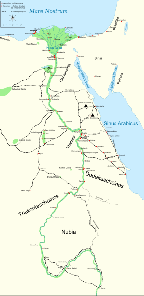
English: Map of Ancient Egypt, showing the Nile up to the fifth cataract, and major cities and sites of the Dynastic period (c. 3150 BC to 30 BC). Jerusalem is shown as reference cities. |
| Datum | |
| Fons |
Own work. See #References for references used creating the map. |
| Auctor | Gigillo83 |
| Other versions |
[]
|


|
This SVG file contains embedded text that can be translated into your language, using any capable SVG editor, text editor or the SVG Translate tool. For more information see: About translating SVG files. |
Potestas usoris
I, the copyright holder of this work, hereby publish it under the following licenses:

|
Licet hoc documentum exscribere vel distribuere vel demutare sub GNU Liberarum Litterarum Licentiae conditionibus in editione 1.2 aut in ulla editione recentiori a Fundatione Liberarum Programmationis Partium publicata; praeterquam Sectiones Immutabiles et Verba Involucra Adversa et Aversa. Licentiae exemplar praesto est in sectione intitulata GNU Free Documentation License. |
This file is licensed under the Creative Commons Attribution-Share Alike 4.0 International, 3.0 Unported, 2.5 Generic, 2.0 Generic and 1.0 Generic license.
- Tibi licet:
- communicare – copiare, distribuere et committere hoc opus
- to remix – to adapt the work
- His condicionibus:
- attributio – You must give appropriate credit, provide a link to the license, and indicate if changes were made. You may do so in any reasonable manner, but not in any way that suggests the licensor endorses you or your use.
- aequa parte – If you remix, transform, or build upon the material, you must distribute your contributions under the same or compatible license as the original.
Tibi typum permissionis ligere licet.
References
Resources used to create the map:
- Shaw, Ian , ed. (2003) The Oxford History of Ancient Egypt, Oxford University Press ISBN: 0-19-280293-3.
- Dr. Peter Der Manuelian , ed. (1998) Egypt: The World of the Pharaohs, Bonner Straße, Köln (Deutschland): Könemann Verlagsgesellschaft mbH ISBN: 3-89508-913-3.
- Digital Egypt - maps. Retrieved on 2007-11-25.
- NASA PIA04957. Retrieved on 2007-11-25.
- NASA PIA02647. Retrieved on 2007-11-25.
- NASA PIA04965. Retrieved on 2007-11-25.
Reference coordinates:
- Sais 30°57′53″N, 30°46′6″E
- Buto 31°11′47″N, 30°44′41″E
- Alexandria 31°11′53″N 29°55′09″E
- Naukratis 30°54' N 30°35'E coordinates here
- Tanis 30°58′37″N, 31°52′48″E
- Avaris 30°47′N, 31°50′E
- Busiris 30°54′40″N, 31°14′40″E
Original upload log
The original description page is/was here. All following user names refer to Commons.
- 2009-01-29 13:21 Bibi Saint-Pol 1577×3219×0 (412000 bytes) (remove wrong text, adjust frame)
- 2009-01-29 12:47 Bibi Saint-Pol 1577×3219×0 (413000 bytes) (added frame)
- 2009-01-29 12:35 Bibi Saint-Pol 1577×3219×0 (412000 bytes) (harmonize colors with the standards + replace unsupported Arial fonts by DejaVu )
- 2008-02-11 06:55 Jeff Dahl 1577×3219×0 (391000 bytes) (sp fx)
- 2007-11-29 02:09 Jeff Dahl 1577×3219×0 (391000 bytes) (Rotate Mediterranean Sea label)
- 2007-11-27 23:32 Jeff Dahl 1577×3219×0 (391000 bytes) (Minor adjustments to Naukratis and Buto)
- 2007-11-27 18:59 Jeff Dahl 1577×3219×0 (391000 bytes) (Cairo and Jerusalem now with black dots/italics)
- 2007-11-23 00:04 Jeff Dahl 1577×3219×0 (391000 bytes) (fx scalebar)
- 2007-11-22 23:56 Jeff Dahl 1577×3219×0 (391000 bytes) ({{Information |Description=A map of ancient Egypt, made with Inkscape |Source=self-made |Date=11-22-07 |Author= Jeff Dahl |Permission= |other_versions={{DerivativeVersions|Ancient Egypt map-ru.svg}} }} )
Historia fasciculi
Presso die vel tempore fasciculum videbis, sicut tunc temporis apparuit.
| Dies/Tempus | Minutio | Dimensiones | Usor | Sententia | |
|---|---|---|---|---|---|
| recentissima | 21:54, 1 Martii 2010 | | 1 577 × 3 219 (1.57 megaocteti) | Gigillo83 | Fix write |
| 15:26, 20 Ianuarii 2010 |  | 1 577 × 3 219 (446 chiliocteti) | Gigillo83 | Aggiungo strada | |
| 14:59, 20 Ianuarii 2010 |  | 1 577 × 3 219 (444 chiliocteti) | Gigillo83 | Aggiunti nomi e corretti luoghi | |
| 12:37, 17 Ianuarii 2010 |  | 1 577 × 3 219 (414 chiliocteti) | Gigillo83 | Aggiunte vie e impianti militari | |
| 11:53, 6 Ianuarii 2010 |  | 1 577 × 3 219 (407 chiliocteti) | Gigillo83 | == {{int:filedesc}} == {{inkscape}} {{Information |Description= {{en|Map of Ancient Egypt, showing the Nile up to the fifth cataract, and major cities and sites of the Dynastic period (c. 3150 BC to 30 BC). Jerusalem is shown as reference cities.}} |Sourc |
Nexus ad fasciculum
Ad hunc fasciculum nectunt:
Usus fasciculi per inceptus Vicimediorum
Quae incepta Vici fasciculo utuntur:
- Usus in bg.wikipedia.org
- Usus in cv.wikipedia.org
- Usus in el.wikipedia.org
- Usus in en.wikipedia.org
- Usus in es.wikipedia.org
- Usus in fr.wikipedia.org
- Usus in he.wikipedia.org
- Usus in it.wikipedia.org
- Limes (storia romana)
- Egitto (provincia romana)
- Prefetto d'Egitto
- Dodecascheno
- Augusto
- Campagne augustee lungo il fronte africano ed arabico
- Limes africano
- Progetto:Laboratorio grafico/Immagini da migliorare/Archivio risolte/39
- Via Hadriana
- Classis Alexandrina
- Politica estera di Augusto
- Utente:Barjimoa/SandboxP
- Usus in mk.wikipedia.org
- Usus in nl.wikipedia.org
- Usus in pl.wikipedia.org
- Usus in ru.wikipedia.org
- Usus in uk.wikipedia.org
- Usus in www.wikidata.org