Fasciculus:Africa relief location map.jpg

Sua resolutio(1 525 × 1 440 elementa imaginalia, magnitudo fasciculi: 522 chiliocteti, typus MIME: image/jpeg)

Hic fasciculus apud Vicimedia Communia iacet; in aliis inceptis adhiberi potest. Contenta paginae descriptionis fasciculi subter monstrantur.

This map image could be re-created using vector graphics as an SVG file. This has several advantages; see Commons:Media for cleanup for more information. If an SVG form of this image is available, please upload it and afterwards replace this template with {{vector version available|new image name}}.


It is recommended to name the SVG file “Africa relief location map.svg”—then the template Vector version available (or Vva) does not need the new image name parameter.

Summarium

Descriptio
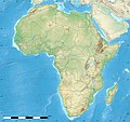
English: Blank physical map of political Africa, for geo-location purposes. Borders as in July 2011.
Français : Carte physique vierge de l'Afrique politique, destinée à la géolocalisation. Frontières telles qu'en juillet 2011.

Lambert azimutal equal-area projection, WGS84 datum

  • Standard meridian: 15°E
  • Standard parallel: 0°
Scale: 1:23,420,000 (precision: 5,855 km)
Datum
Fons

Based upon File:Africa_map_blank.svg created by myself
Sources of data:

  • VMap-0
  • Sudan/South Sudan 2011-07 border: Map Library (data of 2011-07-09)
  • NGDC World Data Bank II
  • CleanTOPO2
  • SRTM30 Plus
Auctor Eric Gaba (Sting - fr:Sting)
Permissio
(Reusing this file)
Attribution and Share-Alike required
Other versions
Camera location0° 00′ 00″ N, 15° 00′ 00″ E Kartographer map based on OpenStreetMap.View this and other nearby images on: OpenStreetMapinfo

Potestas usoris

Eric Gaba, Wikimedia Commons user Sting, the copyright holder of this work, hereby publishes it under the following licenses:
GNU head Licet hoc documentum exscribere vel distribuere vel demutare sub GNU Liberarum Litterarum Licentiae conditionibus in editione 1.2 aut in ulla editione recentiori a Fundatione Liberarum Programmationis Partium publicata; praeterquam Sectiones Immutabiles et Verba Involucra Adversa et Aversa. Licentiae exemplar praesto est in sectione intitulata GNU Free Documentation License.
w:en:Creative Commons
attributio aequa parte
This file is licensed under the Creative Commons Attribution-Share Alike 3.0 Unported license.
Attributio: Eric Gaba, Wikimedia Commons user Sting
Tibi licet:
  • communicare – copiare, distribuere et committere hoc opus
  • to remix – to adapt the work
His condicionibus:
  • attributio – You must give appropriate credit, provide a link to the license, and indicate if changes were made. You may do so in any reasonable manner, but not in any way that suggests the licensor endorses you or your use.
  • aequa parte – If you remix, transform, or build upon the material, you must distribute your contributions under the same or compatible license as the original.
Tibi typum permissionis ligere licet.

Captions

Add a one-line explanation of what this file represents

Items portrayed in this file

depicts Anglica

copyrighted Anglica

Iulius 2010

0°0'0.000"N, 15°0'0.000"E

media type Anglica

image/jpeg

checksum Anglica

95402dc448090b87bd5f4cd3b9d3f36259d6d9f8

data size Anglica

534 629 byte

1 440 pixel

1 525 pixel

Historia fasciculi

Presso die vel tempore fasciculum videbis, sicut tunc temporis apparuit.

(novissima | veterrima) Videre (recentiores 10 | ) (10 | 20 | 50 | 100 | 250 | 500).
Dies/TempusMinutioDimensionesUsorSententia
recentissima12:27, 18 Iulii 2022Minutum speculum redactionis 12:27, 18 Iulii 2022 factae1 525 × 1 440 (522 chiliocteti)M.BittonReverted to version as of 21:54, 5 May 2022 (UTC): per COM:OVERWRITE
11:29, 18 Iulii 2022Minutum speculum redactionis 11:29, 18 Iulii 2022 factae1 627 × 1 536 (472 chiliocteti)Jacob300Reverted to version as of 15:02, 5 May 2022 (UTC)
21:54, 5 Maii 2022Minutum speculum redactionis 21:54, 5 Maii 2022 factae1 525 × 1 440 (522 chiliocteti)M.BittonReverted to version as of 19:03, 14 July 2011 (UTC): per COM:OVERWRITE
15:02, 5 Maii 2022Minutum speculum redactionis 15:02, 5 Maii 2022 factae1 627 × 1 536 (472 chiliocteti)Jacob300Reverted to version as of 17:16, 9 January 2022 (UTC)
18:23, 9 Ianuarii 2022Minutum speculum redactionis 18:23, 9 Ianuarii 2022 factae1 525 × 1 440 (522 chiliocteti)M.BittonReverted to version as of 19:03, 14 July 2011 (UTC): per COM:OVERWRITE
17:16, 9 Ianuarii 2022Minutum speculum redactionis 17:16, 9 Ianuarii 2022 factae1 627 × 1 536 (472 chiliocteti)Jacob300Reverted to version as of 01:08, 19 October 2021 (UTC)
23:16, 19 Octobris 2021Minutum speculum redactionis 23:16, 19 Octobris 2021 factae1 525 × 1 440 (522 chiliocteti)M.BittonReverted to version as of 19:03, 14 July 2011 (UTC): per COM:OVERWRITE
01:08, 19 Octobris 2021Minutum speculum redactionis 01:08, 19 Octobris 2021 factae1 627 × 1 536 (472 chiliocteti)GebageboAdded dotted line to indicate Somaliland
19:03, 14 Iulii 2011Minutum speculum redactionis 19:03, 14 Iulii 2011 factae1 525 × 1 440 (522 chiliocteti)StingSudan/South Sudan 07-2011 border update
13:31, 19 Iulii 2010Minutum speculum redactionis 13:31, 19 Iulii 2010 factae1 525 × 1 440 (424 chiliocteti)StingColor profile
(novissima | veterrima) Videre (recentiores 10 | ) (10 | 20 | 50 | 100 | 250 | 500).

Ad hunc fasciculum nectit:

Usus fasciculi per inceptus Vicimediorum

Metadata