Fasciculus:RomanEmpire 117 - Moesia Superior and Moesia Inferior.svg

Size of this PNG preview of this SVG file: 800 × 587 elementa imaginalia. Aliae mensurae: 320 × 235 elementa imaginalia | 640 × 470 elementa imaginalia | 1 024 × 752 elementa imaginalia | 1 280 × 939 elementa imaginalia | 2 560 × 1 879 elementa imaginalia | 2 180 × 1 600 elementa imaginalia.
Sua resolutio (fasciculus SVG, nominale 2 180 × 1 600 elementa imaginalia, magnitudo fasciculi: 1.87 megaocteti)
Summarium
| Descriptio |
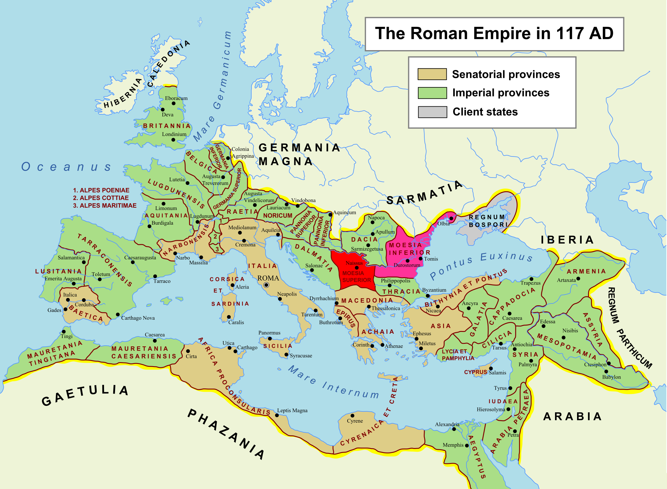
English: Roman Empire in 117 AD. The two Roman provinces, Moesia Superior and Moesia Inferior, are highlighted in red and pink, respectively. See Moesia in English Wikipedia. Derived from File:RomanEmpire 117.svg. Description of the original work: Own work. The maximum extent of the Roman Empire. Superimposed on a physical map. Senatorial Provinces Imperial Provinces Client States Español: Trabajo propio. Máxima extensión del Imperio Romano. Superpuesto en un mapa físico. Deutsch: Das Römische Reich zur Zeit seiner maximalen Ausehnung unter Trajan, 117 n. Chr. Senatorische Provinz Kaiserliche Provinz Klientelkönigtum |
||
| Datum | (UTC) | ||
| Fons |
This file was derived from: RomanEmpire 117.svg: |
||
| Auctor |
|
||
| SVG genesis | This W3C-invalid map was created with Adobe Illustrator.
|
Potestas usoris
I, the copyright holder of this work, hereby publish it under the following license:
| I, the copyright holder of this work, release this work into the public domain. This applies worldwide. In some countries this may not be legally possible; if so: I grant anyone the right to use this work for any purpose, without any conditions, unless such conditions are required by law. |
Original upload log
This image is a derivative work of the following images:
- File:RomanEmpire_117.svg licensed with PD-self
- 2009-05-03T23:52:59Z Amadscientist 2180x1600 (2057461 Bytes) Returning map to last revision by [[User:Richardprins|Richardprins]] Gradient fill to dramatic and loses some titles and graphics.
- 2009-05-03T11:37:15Z Amadscientist 2180x1600 (2059503 Bytes) Gradient
- 2009-05-03T11:36:45Z Amadscientist 2180x1600 (2059503 Bytes) Gradient
- 2009-03-27T22:13:04Z Richardprins 2180x1600 (2057446 Bytes) Version with the latest revisions mostly from ArdadN and one from yug2
- 2008-09-06T13:38:51Z EliasAlucard 2180x1600 (635041 Bytes)
- 2007-12-25T11:51:23Z File Upload Bot (Magnus Manske) 2180x1600 (567550 Bytes) {{BotMoveToCommons|en.wikipedia}} {{Information |Description={{en|Own work. The maximum extent of the Roman Empire. Superimposed on a physical map.}} |Source=Transfered from [http://en.wikipedia.org en.wikipedia] |Date=2007-
Uploaded with derivativeFX
Historia fasciculi
Presso die vel tempore fasciculum videbis, sicut tunc temporis apparuit.
| Dies/Tempus | Minutio | Dimensiones | Usor | Sententia | |
|---|---|---|---|---|---|
| recentissima | 11:42, 13 Maii 2012 | | 2 180 × 1 600 (1.87 megaocteti) | 배우는사람 | == {{int:filedesc}} == {{Information |Description={{en|Roman Empire in 117 AD. The two Roman provinces, Moesia Superior and Moesia Inferior, are highlighted in red and pink, respectively. See Moesiain English Wikipedia. Derived from [[:Fi... |
Nexus ad fasciculum
Ad hunc fasciculum nectit:
Usus fasciculi per inceptus Vicimediorum
Quae incepta Vici fasciculo utuntur:
- Usus in en.wikipedia.org
- Usus in ko.wikipedia.org