Fasciculus:Republic of Lucca, Sanson-Jaillot 1672.png

Mensura huius perspectionis: 800 × 450 elementa imaginalia. Aliae mensurae: 320 × 180 elementa imaginalia | 640 × 360 elementa imaginalia | 1 024 × 576 elementa imaginalia | 1 280 × 720 elementa imaginalia | 1 920 × 1 080 elementa imaginalia.
Sua resolutio (1 920 × 1 080 elementa imaginalia, magnitudo fasciculi: 3.46 megaocteti, typus MIME: image/png)
Summarium
| Descriptio |
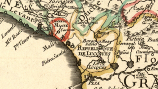
English: Detail of a French map of Italy published in the seconf hald of the 17th century showing the territory of the Republic of Lucca ("République de Lucques"). The enclave of Pietrasanta belonged to the Grand Duchy of Tuscany. Lucca was bordered to the northwest by the Duchy of Massa-Carrara, to the north by the Duchy of Modena, and to the east and south by the Grand Duchy of Tuscany. The map was designed by Guillaume Sanson and published in Paris by Hubert Jaillot in 1672. Title of the map: L'Italie divisée suivant l'estendue de toutes ses souverainetés: qui sont les Estats de l'Eglise, du Roy-Catholique qui comprennent les Royaumes de Naples, de Sicile, de Sardaigne, le Duchfé de Milan &c. |
| Datum | |
| Fons | Moll's map collection |
| Auctor | Guillaume Sanson (1630–1703) |
Potestas usoris
|
This work is in the public domain in its country of origin and other countries and areas where the copyright term is the author's life plus 100 years or fewer. | |
| This file has been identified as being free of known restrictions under copyright law, including all related and neighboring rights. | |
Historia fasciculi
Presso die vel tempore fasciculum videbis, sicut tunc temporis apparuit.
| Dies/Tempus | Minutio | Dimensiones | Usor | Sententia | |
|---|---|---|---|---|---|
| recentissima | 18:24, 8 Septembris 2018 | | 1 920 × 1 080 (3.46 megaocteti) | Lubiesque | User created page with UploadWizard |
Nexus ad fasciculum
Ad hunc fasciculum nectit: