Fasciculus:Quebec - Arrondissements.svg

Size of this PNG preview of this SVG file: 623 × 600 elementa imaginalia. Aliae mensurae: 249 × 240 elementa imaginalia | 498 × 480 elementa imaginalia | 798 × 768 elementa imaginalia | 1 063 × 1 024 elementa imaginalia | 2 127 × 2 048 elementa imaginalia | 1 133 × 1 091 elementa imaginalia.
Sua resolutio (fasciculus SVG, nominale 1 133 × 1 091 elementa imaginalia, magnitudo fasciculi: 26 chiliocteti)
Summarium
| Descriptio |
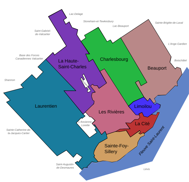
Français : Carte des arrondissements de la ville de Québec (Québec, Canada) en 2007.
English: Maps of the Boroughs ("Arrondissements") of Quebec City (Quebec, Canada), 2007. |
||
| Datum | |||
| Fons | Own work, made with Inkscape | ||
| Auctor | User:Boréal | ||
| Permissio (Reusing this file) |
|
||
| Other versions |
Version modifiée illustrant les arrondissements le 1er novembre 2009 Modified version illustrating the boroughs on November 1, 2009 |

Historia fasciculi
Presso die vel tempore fasciculum videbis, sicut tunc temporis apparuit.
| Dies/Tempus | Minutio | Dimensiones | Usor | Sententia | |
|---|---|---|---|---|---|
| recentissima | 18:28, 16 Maii 2008 | | 1 133 × 1 091 (26 chiliocteti) | Essin | Spelling edit: Stoneham-et-Tewksbury -> Stoneham-et-Tewkesbury |
| 20:43, 9 Decembris 2007 |  | 1 133 × 1 091 (26 chiliocteti) | Boréal | {{Information |Description= {{fr}} Carte des arrondissements de la ville de Québec (Québec, Canada) en 2007. {{en}} Maps of the Boroughs ("Arrondissements") of Quebec City (Quebec, Canada), 2007. |Source=Own work, made with Inkscape |Date=2007-12-09 |Au | |
| 20:35, 9 Decembris 2007 |  | 1 133 × 1 091 (26 chiliocteti) | Boréal | {{Information |Description= {{fr}} Carte des arrondissements de la ville de Québec (Québec, Canada) en 2007. {{en}} Maps of the Boroughs ("Arrondissements") of Quebec City (Quebec, Canada), 2007. |Source=Own work, made with Inkscape |Date=2007-12-09 |Au | |
| 20:30, 9 Decembris 2007 |  | 1 133 × 1 091 (25 chiliocteti) | Boréal | {{Information |Description= {{fr}} Carte des arrondissements de la ville de Québec (Québec, Canada) en 2007. {{en}} Maps of the Boroughs ("Arrondissements") of Quebec City (Quebec, Canada), 2007. |Source=Own work, made with Inkscape |Date=2007-12-09 |Au |
Nexus ad fasciculum
Ad hunc fasciculum nectit:
Usus fasciculi per inceptus Vicimediorum
Quae incepta Vici fasciculo utuntur:
- Usus in ar.wikipedia.org
- Usus in de.wikipedia.org
- Usus in en.wikipedia.org
- Usus in eo.wikipedia.org
- Usus in fr.wikipedia.org
- Usus in ru.wikipedia.org