Fasciculus:Possible definitions of the boundary between Europe and Asia.png
Sua resolutio (729 × 1 129 elementa imaginalia, magnitudo fasciculi: 207 chiliocteti, typus MIME: image/png)
Summarium
| Descriptio |
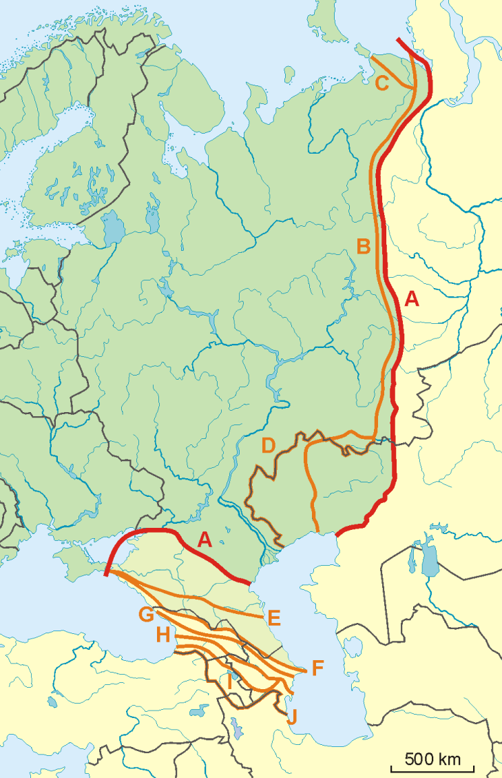
English: A map of possible definitions of the boundary between Asia and Europe.
Note that most of these lines are not referenced to any sources proposing them. The red line marked "A" is apparently the "Strahlenberg" definition commononly taught in Soviet-era Russia. See File:Historical Europe-Asia boundaries 1700 to 1900.png for a map which is actually based on references. The modern mainstream definition used by the UN (see also this) are marked "B" (Urals and Ural River) and "F" (Caucasus watershed). Lines C, D, E, G, H, I and J are currently without reference. Red line - "Strahlenberg" border, allegedly also used by the International Geographical Union [1]
Orange lines - other variants of border:
Polski: Mapa wariantów przebiegów granicy pomiędzy Europą a Azją
linie pomarańczowe - inne warianty przebiegu granicy:
|
| Datum | 09-04-2008 |
| Fons | Opus proprium |
| Auctor | Aotearoa |
| Other versions | Image:TransAsia m.png, File:Historical Europe-Asia boundaries 1700 to 1900.png |
Potestas usoris

|
Licet hoc documentum exscribere vel distribuere vel demutare sub GNU Liberarum Litterarum Licentiae conditionibus in editione 1.2 aut in ulla editione recentiori a Fundatione Liberarum Programmationis Partium publicata; praeterquam Sectiones Immutabiles et Verba Involucra Adversa et Aversa. Licentiae exemplar praesto est in sectione intitulata GNU Free Documentation License. |
- Tibi licet:
- communicare – copiare, distribuere et committere hoc opus
- to remix – to adapt the work
- His condicionibus:
- attributio – You must give appropriate credit, provide a link to the license, and indicate if changes were made. You may do so in any reasonable manner, but not in any way that suggests the licensor endorses you or your use.
- aequa parte – If you remix, transform, or build upon the material, you must distribute your contributions under the same or compatible license as the original.
Historia fasciculi
Presso die vel tempore fasciculum videbis, sicut tunc temporis apparuit.
| Dies/Tempus | Minutio | Dimensiones | Usor | Sententia | |
|---|---|---|---|---|---|
| recentissima | 08:34, 14 Novembris 2022 | | 729 × 1 129 (207 chiliocteti) | Рагин1987 | Dull shade of green up to the "F" line |
| 13:12, 19 Februarii 2022 |  | 729 × 1 129 (205 chiliocteti) | Lojwe | Frame removed | |
| 20:29, 1 Octobris 2010 |  | 735 × 1 134 (156 chiliocteti) | Bogomolov.PL | Reverted to version as of 08:57, 9 April 2008 | |
| 19:44, 1 Octobris 2010 |  | 735 × 1 134 (137 chiliocteti) | Zé Carioca~commonswiki | Trying to fix the error we are facing on the articles. | |
| 15:56, 1 Octobris 2010 |  | 735 × 1 134 (137 chiliocteti) | Gvogas | Inclusion of the Miles Clark route line. (sorry for the tries, my internet gave problems). | |
| 15:55, 1 Octobris 2010 |  | 735 × 1 134 (137 chiliocteti) | Gvogas | Reverted to version as of 15:52, 1 October 2010 | |
| 15:54, 1 Octobris 2010 |  | 735 × 1 134 (137 chiliocteti) | Gvogas | (Inclusion of the Miles Clark route line.) | |
| 15:52, 1 Octobris 2010 |  | 735 × 1 134 (137 chiliocteti) | Gvogas | Inclusion of the Miles Clark route line. | |
| 08:57, 9 Aprilis 2008 |  | 735 × 1 134 (156 chiliocteti) | Aotearoa | {{Information |Description=Map of Europe (green) - Asia (yellow) border. Red line (A) - border accoring to International Geographical Union and most European geographers, orange lines - other variants of border. |Source=własna praca |Date=09-04-2008 | |
Nexus ad fasciculum
Ad hunc fasciculum nectit:
Usus fasciculi per inceptus Vicimediorum
Quae incepta Vici fasciculo utuntur:
- Usus in am.wikipedia.org
- Usus in ar.wikipedia.org
- Usus in arz.wikipedia.org
- Usus in az.wikipedia.org
- Usus in ba.wikipedia.org
- Usus in be.wikipedia.org
- Usus in bn.wikipedia.org
- Usus in ca.wikipedia.org
- Usus in ce.wikipedia.org
- Usus in cs.wikipedia.org
- Usus in de.wikipedia.org
- Eurasien
- Portal:Mauern und Grenzen
- Liste interkontinentaler Staaten
- Wikipedia Diskussion:WikiProjekt Geographie/Archiv/2013-1
- Wikipedia:Löschkandidaten/28. Februar 2016
- Wikipedia Diskussion:WikiProjekt Kategorien/Archiv/2016-II
- Wikipedia Diskussion:Kurier/Archiv/2017/10
- Vorlage Diskussion:Navigationsleiste Kraftwerke
- Wikipedia Diskussion:Kurier/Archiv/2022/08
- Usus in en.wikipedia.org
- Usus in et.wikipedia.org
- Usus in hr.wikipedia.org
- Kategorija:Arktičkooceanski slijev (Europa)
- Kategorija:Arktičkooceanski slijev (Azija)
- Kategorija:Mora Arktičkog oceana
- Kategorija:Reljefni oblici u Arktičkom oceanu
- Kategorija:Mora Arktičkog oceana (Azija)
- Kategorija:Mora Arktičkog oceana (Europa)
- Kategorija:Reljefni oblici u Arktičkom oceanu (Azija)
- Kategorija:Tjesnaci Arktičkog oceana (Europa)
- Kategorija:Vodene mase Arktičkog oceana (Europa)
- Kategorija:Reljefni oblici u Arktičkom oceanu (Europa)
- Kategorija:Tjesnaci Arktičkog oceana (Azija)
- Kategorija:Vodene mase Arktičkog oceana (Azija)
- Kategorija:Karsko more
- Predložak:Granica Europe i Azije
- Kategorija:Zaljevi Arktičkog oceana (Azija)
- Kategorija:Zaljevi Arktičkog oceana (Europa)
- Kategorija:Estuariji Arktičkog oceana (Azija)
- Kategorija:Estuariji Tihog oceana (Azija)
- Usus in hu.wikipedia.org
- Usus in hy.wikipedia.org
View more global usage of this file.