Fasciculus:Karte Tyrrhenisches Meer.jpg

Mensura huius perspectionis: 533 × 599 elementa imaginalia. Aliae mensurae: 213 × 240 elementa imaginalia | 427 × 480 elementa imaginalia | 794 × 893 elementa imaginalia.
Sua resolutio (794 × 893 elementa imaginalia, magnitudo fasciculi: 361 chiliocteti, typus MIME: image/jpeg)
| Descriptio |
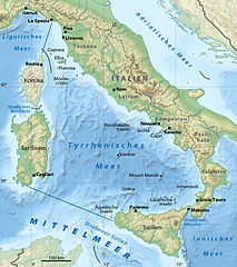
Deutsch: Karte des Tyrrhenischen Meers
English: Map of the Tyrrhenian Sea |
| Datum | (UTC) |
| Fons | |
| Auctor |
|
| This is a retouched picture, which means that it has been digitally altered from its original version. The original can be viewed here: Italy relief location map.jpg:
|
I, the copyright holder of this work, hereby publish it under the following licenses:
This file is licensed under the Creative Commons Attribution-Share Alike 3.0 Unported license.
- Tibi licet:
- communicare – copiare, distribuere et committere hoc opus
- to remix – to adapt the work
- His condicionibus:
- attributio – You must give appropriate credit, provide a link to the license, and indicate if changes were made. You may do so in any reasonable manner, but not in any way that suggests the licensor endorses you or your use.
- aequa parte – If you remix, transform, or build upon the material, you must distribute your contributions under the same or compatible license as the original.

|
Licet hoc documentum exscribere vel distribuere vel demutare sub GNU Liberarum Litterarum Licentiae conditionibus in editione 1.2 aut in ulla editione recentiori a Fundatione Liberarum Programmationis Partium publicata; praeterquam Sectiones Immutabiles et Verba Involucra Adversa et Aversa. Licentiae exemplar praesto est in sectione intitulata GNU Free Documentation License. |
Tibi typum permissionis ligere licet.
Original upload log
This image is a derivative work of the following images:
- File:Italy_relief_location_map.jpg licensed with Cc-by-sa-3.0, GFDL
- 2009-09-14T12:23:52Z Sting 1034x1299 (538646 Bytes) updating borders after important variation (http://www.gazzettaufficiale.it/guridb/dispatcher?service=1&datagu=2009-08-14&task=dettaglio&numgu=188&redaz=009G0127&tmstp=1250276942469) - cf [[:File:Italy_location_map.svg]]
- 2009-05-06T20:31:50Z Sting 1034x1299 (538462 Bytes) == Summary == {{Location|41|21|00|N|12|36|00|E|scale:5000000}} {{Information |Description={{en|Blank physical map of [[:en:Italy|Italy]], for geo-location purpose.}} {{fr|Carte physique vierge de l'[[:fr:Italie|Italie]], des
Uploaded with derivativeFX

|
This map has been made or improved in the German Kartenwerkstatt (Map Lab). You can propose maps to improve as well.
|
Historia fasciculi
Presso die vel tempore fasciculum videbis, sicut tunc temporis apparuit.
| Dies/Tempus | Minutio | Dimensiones | Usor | Sententia | |
|---|---|---|---|---|---|
| recentissima | 09:31, 3 Februarii 2010 | | 794 × 893 (361 chiliocteti) | NordNordWest | + |
| 18:29, 29 Ianuarii 2010 |  | 794 × 893 (360 chiliocteti) | NordNordWest | + | |
| 22:19, 28 Ianuarii 2010 |  | 794 × 893 (270 chiliocteti) | NordNordWest | {{Information |Description={{de|Karte des Tyrrhenischen Meers}} {{en|Map of the Tyrrhenian Sea}} |Source=*File:Italy_relief_location_map.jpg |Date=2010-01-28 22:17 (UTC) |Author=*[[:File:Italy_relie |
Nexus ad fasciculum
Ad hunc fasciculum nectit:
Usus fasciculi per inceptus Vicimediorum
Quae incepta Vici fasciculo utuntur:
- Usus in af.wikipedia.org
- Usus in de.wikipedia.org
- Usus in dsb.wikipedia.org
- Usus in es.wikipedia.org
- Usus in fr.wikipedia.org
- Usus in gl.wikipedia.org
- Usus in hsb.wikipedia.org
- Usus in hu.wikipedia.org
- Usus in ja.wikipedia.org
- Usus in lv.wikipedia.org
- Usus in nl.wikipedia.org
- Usus in sr.wikipedia.org