Fasciculus:Italy c 1810.png
Mensura huius perspectionis: 413 × 599 elementa imaginalia. Aliae mensurae: 165 × 240 elementa imaginalia | 331 × 480 elementa imaginalia | 529 × 768 elementa imaginalia | 1 251 × 1 814 elementa imaginalia.
Sua resolutio (1 251 × 1 814 elementa imaginalia, magnitudo fasciculi: 90 chiliocteti, typus MIME: image/png)
Summarium
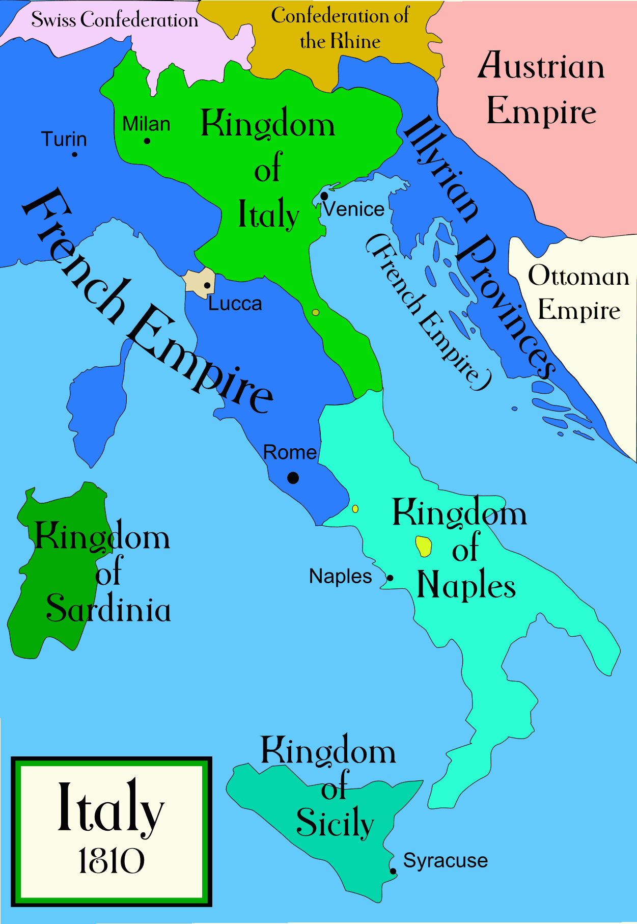
Political map of Italy in the years around 1810, during the Napoleonic era, created by MapMaster. This is a companion map to Image:Italy 1796.png and Image:Italy 1494_v2.png. An SVG version of this map (with Slovenian labels) can be found at Image:Italija_1810_Slovenscina.svg.
Spanish version: File:Italy c 1810-es.png, uploaded by Aibdescalzo

|
This historical map image could be re-created using vector graphics as an SVG file. This has several advantages; see Commons:Media for cleanup for more information. If an SVG form of this image is available, please upload it and afterwards replace this template with
{{vector version available|new image name}}.
It is recommended to name the SVG file “Italy c 1810.svg”—then the template Vector version available (or Vva) does not need the new image name parameter. |
References
- Bjorklund, Oddvar; Holmboe, Haakon; Rohr, Anders (1970) Historical Atlas of the World, Barnes & Noble, NY, SBN: 389-00253-4.
- Other maps, including Image:1french-empire1811.jpg from the 1912 Cambridge Modern History Atlas.
Potestas usoris
I, the copyright holder of this work, hereby publish it under the following licenses:

|
Licet hoc documentum exscribere vel distribuere vel demutare sub GNU Liberarum Litterarum Licentiae conditionibus in editione 1.2 aut in ulla editione recentiori a Fundatione Liberarum Programmationis Partium publicata; praeterquam Sectiones Immutabiles et Verba Involucra Adversa et Aversa. Licentiae exemplar praesto est in sectione intitulata GNU Free Documentation License. |
| This file is licensed under the Creative Commons Attribution-Share Alike 3.0 Unported license. | ||
| ||
| This licensing tag was added to this file as part of the GFDL licensing update. |
Tibi typum permissionis ligere licet.
derivative works
Derivative works of this file:
[]
-
 Arabica
 -
 Anglica
 -
 Hispanica
 -
 Coreana


Historia fasciculi
Presso die vel tempore fasciculum videbis, sicut tunc temporis apparuit.
| Dies/Tempus | Minutio | Dimensiones | Usor | Sententia | |
|---|---|---|---|---|---|
| recentissima | 01:32, 21 Aprilis 2009 | | 1 251 × 1 814 (90 chiliocteti) | Capmo | pallette reduction to 64 colours |
| 04:01, 19 Octobris 2006 |  | 1 251 × 1 814 (385 chiliocteti) | MapMaster | Further improvements to bring it into line with Image:Italy 1796.png | |
| 12:41, 13 Octobris 2006 |  | 1 251 × 1 814 (403 chiliocteti) | MapMaster | Map was slightly improved. | |
| 12:00, 13 Octobris 2006 |  | 1 265 × 1 816 (402 chiliocteti) | MapMaster | Political map of Italy in the years around 1810, during the Napoleonic era, created by MapMaster. |
Nexus ad fasciculum
Ad hunc fasciculum nectit:
Usus fasciculi per inceptus Vicimediorum
Quae incepta Vici fasciculo utuntur:
- Usus in an.wikipedia.org
- Usus in be.wikipedia.org
- Usus in br.wikipedia.org
- Usus in ca.wikipedia.org
- Usus in ceb.wikipedia.org
- Usus in cs.wikipedia.org
- Usus in da.wikipedia.org
- Usus in de.wikipedia.org
- Usus in en.wikipedia.org
- Usus in eo.wikipedia.org
- Usus in es.wikipedia.org
- Usus in et.wikipedia.org
- Usus in fa.wikipedia.org
- Usus in fr.wikipedia.org
- Usus in he.wikipedia.org
- Usus in hi.wikipedia.org
- Usus in hr.wikipedia.org
- Usus in hu.wikipedia.org
- Usus in id.wikipedia.org
- Usus in is.wikipedia.org
- Usus in it.wikipedia.org
- Usus in ja.wikipedia.org
View more global usage of this file.