Fasciculus:Iberia 300BC-en.svg

Size of this PNG preview of this SVG file: 727 × 600 elementa imaginalia. Aliae mensurae: 291 × 240 elementa imaginalia | 582 × 480 elementa imaginalia | 931 × 768 elementa imaginalia | 1 242 × 1 024 elementa imaginalia | 2 484 × 2 048 elementa imaginalia | 924 × 762 elementa imaginalia.
Sua resolutio (fasciculus SVG, nominale 924 × 762 elementa imaginalia, magnitudo fasciculi: 772 chiliocteti)
Summarium

|
This SVG file contains embedded text that can be translated into your language, using any capable SVG editor, text editor or the SVG Translate tool. For more information see: About translating SVG files. |
| Descriptio |
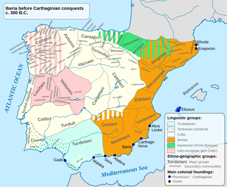
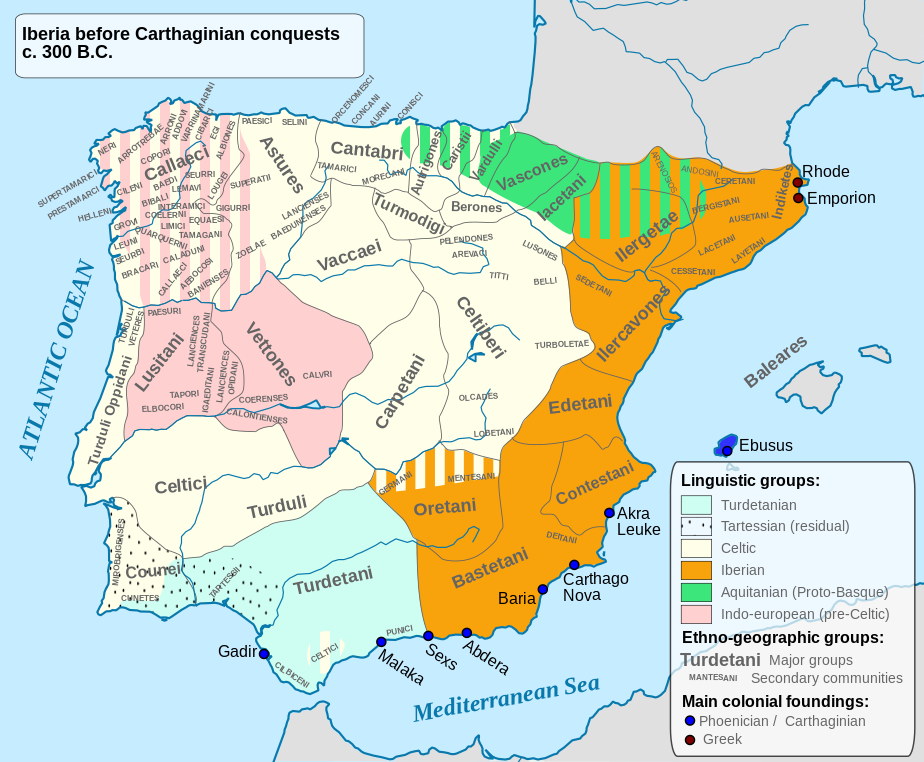
English: Ethnographic and Linguistic Map of the Iberian Peninsula at about 300 BCE (before the Carthaginian conquests). |
||
| Datum | |||
| Fons |
Based on the map done by Portuguese Archeologist Luís Fraga, from the "Campo Arqueológico de Tavira". The reference map can be found at this location [1]. Original source: https://web.archive.org/web/20161105032508/http://geohistorica.net/arkeotavira.com/Mapas/Iberia/Populi.pdf |
||
| Auctor | Alcides Pinto | ||
| Permissio (Reusing this file) |
I, the copyright holder of this work, hereby publish it under the following license:
|
||
| Other versions |
Derivative works of this file: Ethnographic Iberia 200 BCE.PNG Languages of pre-Roman Iberia.jpg |

Historia fasciculi
Presso die vel tempore fasciculum videbis, sicut tunc temporis apparuit.
| Dies/Tempus | Minutio | Dimensiones | Usor | Sententia | |
|---|---|---|---|---|---|
| recentissima | 15:41, 27 Octobris 2023 | | 924 × 762 (772 chiliocteti) | Il Qathar | Reverted to version as of 20:39, 10 August 2012 (UTC) (the most recent upload messed the captions, which are gone). |
| 20:25, 7 Iunii 2022 |  | 924 × 762 (711 chiliocteti) | Coralma* | File uploaded using svgtranslate tool (https://svgtranslate.toolforge.org/). Added translation for nl-informal. | |
| 20:39, 10 Augusti 2012 |  | 924 × 762 (772 chiliocteti) | Galazan | More precise localization of: Indiketes, Ausetani, Layetani, Ilergetae, Ceretani and Andosini | |
| 15:45, 8 Aprilis 2012 |  | 924 × 762 (805 chiliocteti) | Kordas | Fixing Formentera color and showing mixed area in Oretania | |
| 03:42, 8 Aprilis 2012 |  | 924 × 762 (490 chiliocteti) | Kordas | See file talk | |
| 23:03, 26 Aprilis 2010 |  | 924 × 762 (326 chiliocteti) | Alcides Pinto | Solve upload problem | |
| 22:54, 26 Aprilis 2010 |  | 924 × 762 (326 chiliocteti) | Alcides Pinto | {{Information |Description={{en|1=Ethnographic and Linguistic Map of the Iberian Peninsula at about 300 BCE (before the Carthaginian conquests).}} |Source=Based on the map done by Portuguese Archeologist Luís Fraga, from the "Campo Arqueológico de Tavir |
Nexus ad fasciculum
Ad hunc fasciculum nectit:
Usus fasciculi per inceptus Vicimediorum
Quae incepta Vici fasciculo utuntur:
- Usus in ace.wikipedia.org
- Usus in an.wikipedia.org
- Usus in ast.wikipedia.org
- Usus in be.wikipedia.org
- Usus in bg.wikipedia.org
- Usus in br.wikipedia.org
- Usus in ca.wikipedia.org
- Usus in da.wikipedia.org
- Usus in de.wikipedia.org
- Eisenzeit
- Spanische Sprache
- Baskische Sprache
- Iberer
- Keltiberer
- 194 v. Chr.
- Lusitaner
- Geschichte Karthagos
- Keltiberische Sprache
- Keltische Nationen
- Sprachen auf der Iberischen Halbinsel
- Kantabrer
- Benutzer Diskussion:Roxanna/Arbeitsplatz
- Liste antiker Ethnien der Iberischen Halbinsel
- Vettonen
- Turdetaner
- Carpetani
- Edetani
- Benutzer:JEW/Nekropole von El Cascarujo
- Usus in el.wikipedia.org
- Usus in en.wikipedia.org
View more global usage of this file.