Fasciculus:Hanover1720.png
Mensura huius perspectionis: 707 × 600 elementa imaginalia. Aliae mensurae: 283 × 240 elementa imaginalia | 566 × 480 elementa imaginalia | 906 × 768 elementa imaginalia | 1 208 × 1 024 elementa imaginalia | 2 500 × 2 120 elementa imaginalia.
Sua resolutio (2 500 × 2 120 elementa imaginalia, magnitudo fasciculi: 537 chiliocteti, typus MIME: image/png)

|
This map image could be re-created using vector graphics as an SVG file. This has several advantages; see Commons:Media for cleanup for more information. If an SVG form of this image is available, please upload it and afterwards replace this template with
{{vector version available|new image name}}.
It is recommended to name the SVG file “Hanover1720.svg”—then the template Vector version available (or Vva) does not need the new image name parameter. |
Summarium
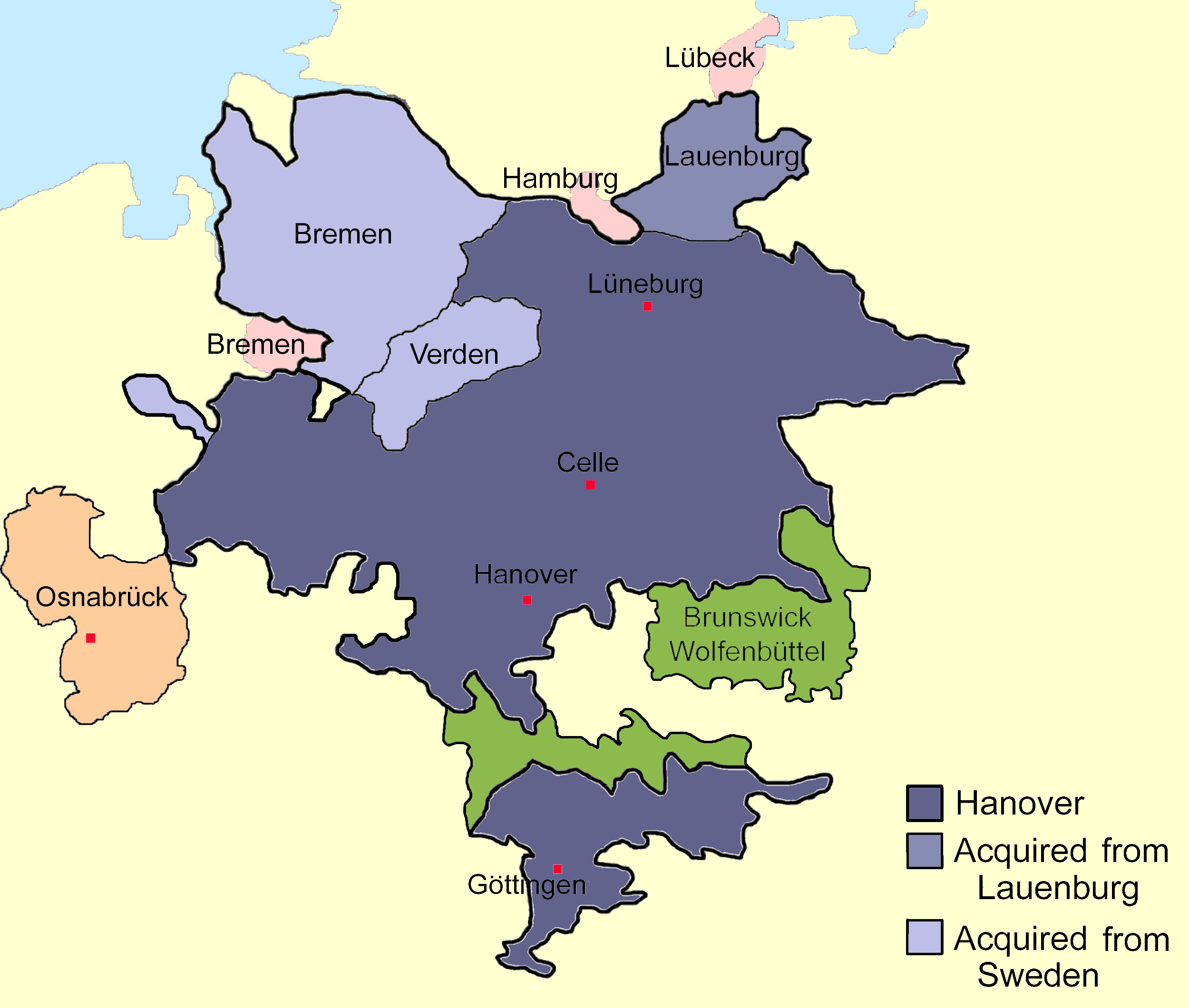
| Descriptio | Sketch map of the state of Hanover, c.1720 showing territorial acquisitions and some neighbouring states and imperial cities; drawn in Adobe Photoshop by hand using a pen tablet. |
| Datum | Dies ignota |
| Fons |
Opus proprium Based on Map 1, page 378, Hatton, Ragnhild (1978) George I: Elector and King, Cambridge, MA: Harvard University Press ISBN: 0-674-34935-0. |
| Auctor | DrKay |
| Other versions |
|


| I, the copyright holder of this work, release this work into the public domain. This applies worldwide. In some countries this may not be legally possible; if so: I grant anyone the right to use this work for any purpose, without any conditions, unless such conditions are required by law. |
Historia fasciculi
Presso die vel tempore fasciculum videbis, sicut tunc temporis apparuit.
| Dies/Tempus | Minutio | Dimensiones | Usor | Sententia | |
|---|---|---|---|---|---|
| recentissima | 22:01, 24 Novembris 2009 | | 2 500 × 2 120 (537 chiliocteti) | The Illusional Ministry | Changed colours |
| 22:00, 24 Novembris 2009 |  | 2 500 × 2 120 (537 chiliocteti) | The Illusional Ministry | Changed colours | |
| 07:56, 20 Augusti 2007 |  | 2 500 × 2 120 (592 chiliocteti) | DrKay | {{Information |Description=Sketch map of the state of Hanover, c.1720 showing territorial acquisitions and some neighbouring states and imperial cities; drawn in Adobe Photoshop by hand using a pen tablet. |Source=self-made |Date= |Author= [[User:DrKierna |
Nexus ad fasciculum
Ad hunc fasciculum nectit:
Usus fasciculi per inceptus Vicimediorum
Quae incepta Vici fasciculo utuntur:
- Usus in ar.wikipedia.org
- Usus in be.wikipedia.org
- Usus in ckb.wikipedia.org
- Usus in cs.wikipedia.org
- Usus in da.wikipedia.org
- Usus in el.wikipedia.org
- Usus in en.wikipedia.org
- Usus in es.wikipedia.org
- Usus in et.wikipedia.org
- Usus in fr.wikipedia.org
- Usus in he.wikipedia.org
- Usus in hu.wikipedia.org
- Usus in it.wikipedia.org
- Usus in ja.wikipedia.org
- Usus in vi.wikipedia.org
- Usus in zh.wikipedia.org