Fasciculus:Haiti topographic map-fr.png

Mensura huius perspectionis: 800 × 598 elementa imaginalia. Aliae mensurae: 320 × 239 elementa imaginalia | 640 × 478 elementa imaginalia | 1 024 × 765 elementa imaginalia | 1 280 × 956 elementa imaginalia | 1 739 × 1 299 elementa imaginalia.
Sua resolutio (1 739 × 1 299 elementa imaginalia, magnitudo fasciculi: 2.21 megaocteti, typus MIME: image/png)
Summarium
| Descriptio |
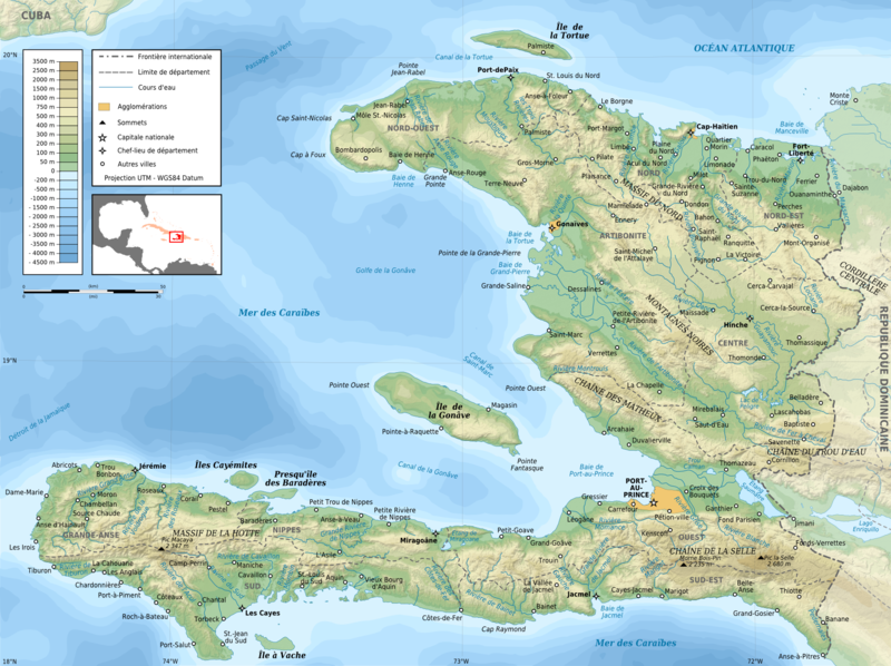
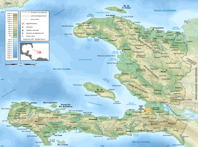
English: Topographic map of Haiti in French. Use the SVG version for translations and alterations, then update this one.
Français : Carte topographique d'Haïti en français. Utiliser la version SVG pour les traductions et les changements, puis mettre à jour celle-ci.
|
| Datum | |
| Fons |
Own work. Sources of data:
|
| Auctor | Rémi Kaupp |
| Other versions |
[]
|


Potestas usoris
English: This map has been created by Rémi Kaupp (User:Korrigan) and released under the license(s) stated below. You are free to use it for any purpose as long as you credit me and follow the terms of the license. You may need to credit the sources of data of the map (please check). Example:
Français : Cette carte a été créée par Rémi Kaupp (User:Korrigan) et placée sous la ou les licence(s) ci-dessous. Vous êtes libre de la réutiliser, tant que vous me citez en tant qu'auteur et suivez les instructions de la licence. Certaines sources de données de la carte doivent peut-être être créditées, veuillez vérifier. Exemple :
|
 |
I, the copyright holder of this work, hereby publish it under the following licenses:

|
Licet hoc documentum exscribere vel distribuere vel demutare sub GNU Liberarum Litterarum Licentiae conditionibus in editione 1.2 aut in ulla editione recentiori a Fundatione Liberarum Programmationis Partium publicata; praeterquam Sectiones Immutabiles et Verba Involucra Adversa et Aversa. Licentiae exemplar praesto est in sectione intitulata GNU Free Documentation License. |
This file is licensed under the Creative Commons Attribution-Share Alike 4.0 International, 3.0 Unported, 2.5 Generic, 2.0 Generic and 1.0 Generic license.
- Tibi licet:
- communicare – copiare, distribuere et committere hoc opus
- to remix – to adapt the work
- His condicionibus:
- attributio – You must give appropriate credit, provide a link to the license, and indicate if changes were made. You may do so in any reasonable manner, but not in any way that suggests the licensor endorses you or your use.
- aequa parte – If you remix, transform, or build upon the material, you must distribute your contributions under the same or compatible license as the original.
Tibi typum permissionis ligere licet.
Historia fasciculi
Presso die vel tempore fasciculum videbis, sicut tunc temporis apparuit.
| Dies/Tempus | Minutio | Dimensiones | Usor | Sententia | |
|---|---|---|---|---|---|
| recentissima | 19:26, 11 Martii 2009 | | 1 739 × 1 299 (2.21 megaocteti) | Korrigan | + masque blanc pour pays étrangers |
| 22:49, 9 Martii 2009 |  | 1 739 × 1 299 (2.22 megaocteti) | Korrigan | Recadrage de la carte de situation | |
| 22:30, 9 Martii 2009 |  | 1 739 × 1 299 (2.22 megaocteti) | Korrigan | - cadre, + chaînes de montagne, meilleure carte de situation | |
| 00:37, 7 Martii 2009 |  | 1 739 × 1 299 (2.21 megaocteti) | Korrigan | == Description == {{Information |Description={{en|Topographic map of Haiti in French}} {{fr|Carte topographique d'Haïti en français.}} * UTM projection, WGS84 datum * The shaded relief is an embedded raster image, delete it to make the file smaller. |
Nexus ad fasciculum
Ad hunc fasciculum nectit:
Usus fasciculi per inceptus Vicimediorum
Quae incepta Vici fasciculo utuntur:
- Usus in ar.wikipedia.org
- Usus in avk.wikipedia.org
- Usus in ca.wikipedia.org
- Usus in ceb.wikipedia.org
- Usus in de.wikipedia.org
- Usus in en.wikipedia.org
- Usus in eo.wikipedia.org
- Usus in es.wikipedia.org
- Usus in fa.wikipedia.org
- Usus in fr.wikipedia.org
- Discussion Wikipédia:Atelier graphique/Archive 4
- Géographie d'Haïti
- Artibonite (fleuve)
- Projet:Cartographie/Cartes standards/Pays
- Histoire de la caféiculture
- Wikipédia:Image du jour/mai 2009
- Wikipédia:Image du jour/12 mai 2009
- Massif de la Hotte
- Chaîne de la Selle
- Rivière Soliette
- Chaîne des Matheux
- Massif des Montagnes Noires
- Rivière de Montrouis
- Chaîne du Trou d'Eau
- Massif du Nord
- Rivière des Ténèbres
- Rivière Libon
- Rivière Macassia
- Rivière Fer à Cheval
- Pedernales (rivière)
- Rivière Limbé
- Grande Rivière du Nord
- Rivière Bouyaha
- Liste de catastrophes naturelles en Haïti
- Rivière Guayamouc
- Rivière l'Estère
- Rivière Blanche (département de l'Ouest)
- Rivière Grise
- Rivière de Cavaillon
- Ravine du Sud
- Liste des cours d'eau d'Haïti
- Rivière Torbeck
- Acul du Sud
- Rivière Bainet
- Grande Rivière de Nippes
- Rivière de la Cosse
View more global usage of this file.