Fasciculus:Greece topo.jpg

Mensura huius perspectionis: 704 × 600 elementa imaginalia. Aliae mensurae: 282 × 240 elementa imaginalia | 563 × 480 elementa imaginalia | 901 × 768 elementa imaginalia | 1 202 × 1 024 elementa imaginalia | 1 400 × 1 193 elementa imaginalia.
Sua resolutio (1 400 × 1 193 elementa imaginalia, magnitudo fasciculi: 547 chiliocteti, typus MIME: image/jpeg)
Summarium
| Descriptio |
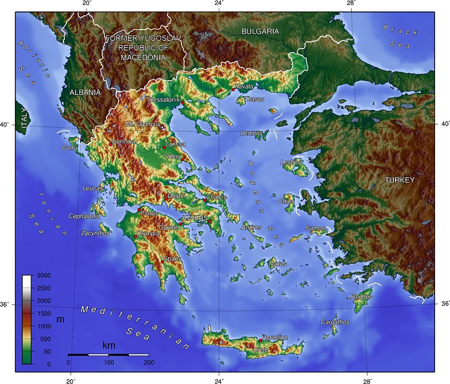
English: Topographic map of Greece.
Deutsch: Topografische Karte Griechenlands. |
| Datum | |
| Fons | Originally created for English Wikipedia by Captain Blood. |
| Auctor | Captain Blood |
Potestas usoris

|
This map has been uploaded by Electionworld from en.wikipedia.org to enable the |
The map has been created with the Generic Mapping Tools: https://www.generic-mapping-tools.org/ using one or more of these public-domain datasets for the relief:
|

|
Licet hoc documentum exscribere vel distribuere vel demutare sub GNU Liberarum Litterarum Licentiae conditionibus in editione 1.2 aut in ulla editione recentiori a Fundatione Liberarum Programmationis Partium publicata; praeterquam Sectiones Immutabiles et Verba Involucra Adversa et Aversa. Licentiae exemplar praesto est in sectione intitulata GNU Free Documentation License. |
| This file is licensed under the Creative Commons Attribution-Share Alike 3.0 Unported license. | ||
| ||
| This licensing tag was added to this file as part of the GFDL licensing update. |
Historia fasciculi
Presso die vel tempore fasciculum videbis, sicut tunc temporis apparuit.
| Dies/Tempus | Minutio | Dimensiones | Usor | Sententia | |
|---|---|---|---|---|---|
| recentissima | 20:27, 20 Decembris 2006 | | 1 400 × 1 193 (547 chiliocteti) | Electionworld | {{ew|en|Captain Blood}} {{GMT}} Category:Maps of Greece de:Bild:Griechenland_topo.jpg |
Nexus ad fasciculum
Ad hunc fasciculum nectit:
Usus fasciculi per inceptus Vicimediorum
Quae incepta Vici fasciculo utuntur:
- Usus in ar.wikipedia.org
- Usus in ast.wikipedia.org
- Usus in azb.wikipedia.org
- Usus in az.wikipedia.org
- Usus in be-tarask.wikipedia.org
- Usus in be.wikipedia.org
- Usus in bg.wikipedia.org
- Usus in bn.wikipedia.org
- Usus in br.wikipedia.org
- Usus in ca.wikipedia.org
- Usus in cs.wikipedia.org
- Usus in cy.wikipedia.org
- Usus in de.wikipedia.org
- Usus in de.wikibooks.org
- Usus in el.wikipedia.org
- Έβρος (Θράκη)
- Νέστος
- Άρδας
- Αλιάκμονας
- Ποταμός
- Αχελώος
- Αξιός
- Στρυμόνας
- Αλφειός
- Λουδίας
- Γαλλικός ποταμός
- Θύαμις
- Άραχθος
- Αώος
- Ελλάδα
- Λούρος
- Πηνειός (Ηλεία)
- Κομψάτος
- Πρότυπο:Ποταμοί της Ελλάδας
- Ακραία σημεία της Ελλάδας
- Λίσσος
- Κόσυνθος
- Βοσβόζης
- Γεωγραφία της Ελλάδας
- Αλλαγές γεωγραφικών ονομάτων στην Ελλάδα
- Άγρια ζωή της Ελλάδας
- Usus in en.wikipedia.org
View more global usage of this file.