Fasciculus:Etruscan civilization map.png

Mensura huius perspectionis: 493 × 599 elementa imaginalia. Aliae mensurae: 197 × 240 elementa imaginalia | 395 × 480 elementa imaginalia | 994 × 1 208 elementa imaginalia.
Sua resolutio (994 × 1 208 elementa imaginalia, magnitudo fasciculi: 361 chiliocteti, typus MIME: image/png)
Summarium
| Descriptio |
[]
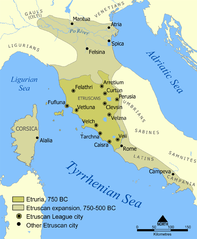
Català: Un mapa que mostra l'extensió d'Etruria i la civilització etrusca. El mapa inclou les 12 ciutats de la Lliga Etrusca i ciutats notables fundades pels etruscs. Les dates del mapa són una aproximació. English: A map showing the extent of Etruria and the Etruscan civilization. The map includes the 12 cities of the Etruscan League and notable cities founded by the Etruscans. The dates on the map are an approximation. Español: Expansión etrusca entre el 750 y el 500 a. de C., las ciudades de la Liga etrusca y otras notables fundadas por los etruscos. Português: Mapa da expansão etrusca entre 750-500 Suomi: Kartta Etruriasta ja etruskien sivilisaatiosta sen ollessa laajimmillaan. Karttaan on merkitty etruskien kaupunkiliiton 12 kaupunkia sekä muita etruskien perustamia merkittäviä kaupunkeja. Ελληνικά: Χάρτης της Ετρουρίας Беларуская: Карта паказвае абрысы Этрурыі і этрускай цывілізацыі. Яна ўключае 12 асноўных гарадоў этрускай лігі і іншыя горады, заснаваныя этрускамі. ქართული: ეტრუსკული ცივილიზაციის რუკა. עברית : מפה המציגה את היקף אטרוריה והציוויליזציה האטרוסקית. המפה כוללת את 12 ערי הליגה האטרוסקית וערים בולטות שנוסדו על ידי האטרוסקים. התאריכים במפה הם בקירוב. العربية : خريطة تُظهر نطاق الحضارتين الإترورياويَّة والإتروسكانيَّة. تتضمَّن هذه الخريطة 12 مدينة انتمت إلى الرابطة الإتروسكانيَّة ومُدن مُهمَّة وبارزة أُخرى كانت قائمة ضمن بلاد الإتروسكان. |
||
| Datum | |||
| Fons | Based on a map from The National Geographic Magazine Vol.173 No.6 June 1988. | ||
| Auctor | NormanEinstein | ||
| Permissio (Reusing this file) |
GNU-FDL | ||
| Other versions |
[]
|


Potestas usoris
I, the copyright holder of this work, hereby publish it under the following licenses:

|
Licet hoc documentum exscribere vel distribuere vel demutare sub GNU Liberarum Litterarum Licentiae conditionibus in editione 1.2 aut in ulla editione recentiori a Fundatione Liberarum Programmationis Partium publicata; praeterquam Sectiones Immutabiles et Verba Involucra Adversa et Aversa. Licentiae exemplar praesto est in sectione intitulata GNU Free Documentation License. |
| This file is licensed under the Creative Commons Attribution-Share Alike 3.0 Unported license. | ||
| ||
| This licensing tag was added to this file as part of the GFDL licensing update. |
Tibi typum permissionis ligere licet.
Historia fasciculi
Presso die vel tempore fasciculum videbis, sicut tunc temporis apparuit.
| Dies/Tempus | Minutio | Dimensiones | Usor | Sententia | |
|---|---|---|---|---|---|
| recentissima | 12:18, 22 Iulii 2010 | | 994 × 1 208 (361 chiliocteti) | Ras67 | cropped |
| 20:10, 6 Februarii 2006 |  | 1 000 × 1 214 (525 chiliocteti) | NormanEinstein | Modified tribe names. | |
| 14:01, 27 Iulii 2005 |  | 800 × 971 (405 chiliocteti) | NormanEinstein | Corrected several typos. | |
| 21:03, 26 Iulii 2005 |  | 800 × 971 (416 chiliocteti) | NormanEinstein | A map showing the extent of Etruria and the Etruscan civilization. The map includes the 12 cities of the Etruscan League and notable cities founded by the Etruscans. Created by NormanEinstein, July 26, 2005. {{GFDL-self}} |
Nexus ad fasciculum
Ad hunc fasciculum nectunt:
Usus fasciculi per inceptus Vicimediorum
Quae incepta Vici fasciculo utuntur:
- Usus in af.wikipedia.org
- Usus in ar.wikipedia.org
- Usus in ast.wikipedia.org
- Usus in azb.wikipedia.org
- Usus in az.wikipedia.org
- Usus in bg.wikipedia.org
- Usus in bh.wikipedia.org
- Usus in cs.wikipedia.org
- Usus in cy.wikipedia.org
- Usus in da.wikipedia.org
- Usus in de.wikipedia.org
- Usus in en.wikipedia.org
- Etruscan language
- Etruscan civilization
- Etruria
- 800 BC
- Classical antiquity
- Campaign history of the Roman military
- User:NormanEinstein
- Caere
- Battle of Lake Vadimo (283 BC)
- User:NormanEinstein/gallery
- Talk:Etruscan civilization/Archive 1
- Etruscan history
- Etruscan cities
- Etruscan origins
- Padanian Etruria
- Lega dei popoli
- User:Etruscanman114
- Portal:Civilizations
- User:Falcaorib
- User:Est. 2021/sandbox/Etruscan
- Usus in en.wikiquote.org
- Usus in eo.wikipedia.org
- Usus in es.wikipedia.org
- Usus in et.wikipedia.org
View more global usage of this file.