Fasciculus:EnglandCountiesCere.png
Nulla maior resolutio exstat.
EnglandCountiesCere.png (392 × 485 elementa imaginalia, magnitudo fasciculi: 11 chiliocteti, typus MIME: image/png)

|
This map image could be re-created using vector graphics as an SVG file. This has several advantages; see Commons:Media for cleanup for more information. If an SVG form of this image is available, please upload it and afterwards replace this template with
{{vector version available|new image name}}.
It is recommended to name the SVG file “EnglandCountiesCere.svg”—then the template Vector version available (or Vva) does not need the new image name parameter. |
From en:Image:EnglandCountiesCere.png
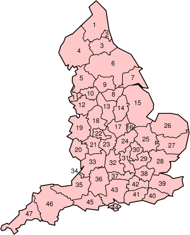
The Ceremonial counties of England, also known as the Geographic counties, numbered.
Original uploader User:Morwen
| This file is licensed under the Creative Commons Attribution-Share Alike 3.0 Unported license. Subject to disclaimers. | ||
| ||
| This licensing tag was added to this file as part of the GFDL licensing update. |

|
Licet hoc documentum exscribere vel distribuere vel demutare sub GNU Liberarum Litterarum Licentiae conditionibus in editione 1.2 aut in ulla editione recentiori a Fundatione Liberarum Programmationis Partium publicata; praeterquam Sectiones Immutabiles et Verba Involucra Adversa et Aversa. Licentiae exemplar praesto est in sectione intitulata GNU Free Documentation License. Subject to disclaimers. |
Historia fasciculi
Presso die vel tempore fasciculum videbis, sicut tunc temporis apparuit.
| Dies/Tempus | Minutio | Dimensiones | Usor | Sententia | |
|---|---|---|---|---|---|
| recentissima | 00:53, 22 Iunii 2005 | | 392 × 485 (11 chiliocteti) | Airunp | From en:Image:EnglandCountiesCere.png {{GFDL}} Category:Maps of England |
Nexus ad fasciculum
Ad hunc fasciculum nectit:
Usus fasciculi per inceptus Vicimediorum
Quae incepta Vici fasciculo utuntur:
- Usus in an.wikipedia.org
- Usus in ast.wikipedia.org
- Usus in ca.wikipedia.org
- Usus in cs.wikipedia.org
- Usus in cy.wikipedia.org
- Usus in da.wikipedia.org
- Usus in de.wikipedia.org
- Usus in es.wikipedia.org
- Usus in eu.wikipedia.org
- Usus in gl.wikipedia.org
- Usus in lv.wikipedia.org
- Usus in nn.wikipedia.org
- Usus in no.wikipedia.org
- Usus in oc.wikipedia.org
- Usus in pl.wikipedia.org
- Usus in pt.wikipedia.org
- Usus in sk.wikipedia.org
- Usus in sv.wikipedia.org
- Usus in www.wikidata.org