Fasciculus:Basin of Mexico 1519 map-en.svg

Size of this PNG preview of this SVG file: 449 × 599 elementa imaginalia. Aliae mensurae: 180 × 240 elementa imaginalia | 360 × 480 elementa imaginalia | 576 × 768 elementa imaginalia | 768 × 1 024 elementa imaginalia | 1 536 × 2 048 elementa imaginalia | 1 412 × 1 883 elementa imaginalia.
Sua resolutio (fasciculus SVG, nominale 1 412 × 1 883 elementa imaginalia, magnitudo fasciculi: 526 chiliocteti)
Summarium
| Descriptio |
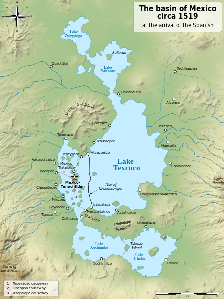
English: Map of the basin of Mexico circa 1519, at the arrival of the Spanish.
Español: Mapa de la cuenca de México acerca 1519, a la llegada de los españoles
Français : Carte du bassin de Mexico vers 1519, à l'arrivée des Espagnols. |
| Datum | (UTC) |
| Fons |
|
| Auctor |
|
| Other versions |
[]
|
| SVG genesis |


| Camera location | | View this and other nearby images on: OpenStreetMap |
|---|
Potestas usoris
I, the copyright holder of this work, hereby publish it under the following licenses:
| Copyleft: This work of art is free; you can redistribute it and/or modify it according to terms of the Free Art License. You will find a specimen of this license on the Copyleft Attitude site as well as on other sites. |
This file is licensed under the Creative Commons Attribution-Share Alike 4.0 International, 3.0 Unported, 2.5 Generic, 2.0 Generic and 1.0 Generic license.
- Tibi licet:
- communicare – copiare, distribuere et committere hoc opus
- to remix – to adapt the work
- His condicionibus:
- attributio – You must give appropriate credit, provide a link to the license, and indicate if changes were made. You may do so in any reasonable manner, but not in any way that suggests the licensor endorses you or your use.
- aequa parte – If you remix, transform, or build upon the material, you must distribute your contributions under the same or compatible license as the original.
Tibi typum permissionis ligere licet.
Original upload log
This image is a derivative work of the following images:
- File:Lago_de_Texcoco-posclásico.png licensed with PD-self, PD-self/fr
- 2006-09-19T01:46:06Z Yavidaxiu 1412x1644 (344123 Bytes) {{Information |Description={{es|Mapa de la cuenca de México a la llegada de los españoles}} |Source=Trabajo propio |Date=18 de septiembre de 2006 |Author=Yavidaxiu |Permission={{PD-self}} |other_versions= }} [[Category:Map
- File:Valley_of_Mexico_c.1519-fr.svg licensed with Cc-by-sa-2.5,2.0,1.0, Cc-by-sa-3.0-migrated, GFDL
- 2007-09-11T14:00:14Z Historicair 731x849 (270643 Bytes)
- 2007-09-11T13:51:30Z Historicair 731x849 (272818 Bytes) {{Information |Description={{fr|Les environs de Tenochtitlan vers 1519}} {{en|Valley of Mexico circa 1519}} |Source=Own work |Date=11/09/2007 |Author=~~~~ |Permission={{self2|GFDL|cc-by-sa-2.5,2.0,1.0}} |other_versions= }} {{
Uploaded with derivativeFX
Historia fasciculi
Presso die vel tempore fasciculum videbis, sicut tunc temporis apparuit.
| Dies/Tempus | Minutio | Dimensiones | Usor | Sententia | |
|---|---|---|---|---|---|
| recentissima | 20:29, 28 Ianuarii 2021 | | 1 412 × 1 883 (526 chiliocteti) | Sémhur | Huexotla <=> Coatlinchán |
| 05:40, 17 Iulii 2013 |  | 1 412 × 1 883 (525 chiliocteti) | Citypeek | Enlargement of the legenda in the upper right corner. | |
| 05:33, 17 Iulii 2013 |  | 1 412 × 1 883 (533 chiliocteti) | Citypeek | Corrected two errors. Valid SVG now. | |
| 18:37, 8 Februarii 2010 |  | 1 412 × 1 883 (533 chiliocteti) | Sémhur | + relief and some improvements | |
| 09:45, 31 Ianuarii 2010 |  | 1 412 × 1 645 (99 chiliocteti) | Sémhur | == {{int:filedesc}} == {{Information |Description= {{en|Map of the basin of Mexico circa 1519, at the arrival of the Spanish.}} {{es|Mapa de la cuenca de México acerca 1519, a la llegada de los españoles}} {{fr|Carte du bassin de Mexico vers 1519, à l |
Nexus ad fasciculum
Ad hunc fasciculum nectit:
Usus fasciculi per inceptus Vicimediorum
Quae incepta Vici fasciculo utuntur:
- Usus in azb.wikipedia.org
- Usus in ba.wikipedia.org
- Usus in br.wikipedia.org
- Usus in de.wikipedia.org
- Usus in en.wikipedia.org
- Aztecs
- Iztapalapa
- Lake Texcoco
- Valley of Mexico
- Aztec Empire
- Altiplano Cundiboyacense
- Tenayuca
- User:Kazkaskazkasako/Books/History
- User:Maunus/sandbox
- List of conflicts in Mexico
- Lake Zumpango
- Lake Tauca
- User:SomeGuyWhoRandomlyEdits/List of conflicts in Mexico
- Sierra de Guadalupe, Mexico
- Battle of Colhuacatonco
- Usus in en.wikibooks.org
- Usus in es.wikipedia.org
- Usus in fi.wikibooks.org
- Usus in hr.wikipedia.org
- Usus in hy.wikipedia.org
- Usus in id.wikipedia.org
- Usus in ja.wikipedia.org
- Usus in ka.wikipedia.org
- Usus in nl.wikipedia.org
- Usus in nv.wikipedia.org
- Usus in pl.wikipedia.org
- Usus in rue.wikipedia.org
- Usus in ru.wikipedia.org
- Usus in sv.wikipedia.org
- Usus in ta.wikipedia.org
- Usus in tr.wikipedia.org
- Usus in vi.wikipedia.org