Fasciculus:Ancient Levant routes.png

Mensura huius perspectionis: 800 × 541 elementa imaginalia. Aliae mensurae: 320 × 217 elementa imaginalia | 640 × 433 elementa imaginalia | 919 × 622 elementa imaginalia.
Sua resolutio (919 × 622 elementa imaginalia, magnitudo fasciculi: 290 chiliocteti, typus MIME: image/png)
Summarium
| Descriptio |
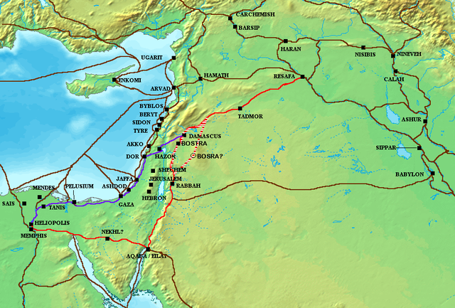
The en:Via Maris (purple), King's Highway (in red), and other ancient en:Levantine en:trade routes, c. en:1300 BCE en:Category:Historical maps by User:Briangotts |
| Datum | 24 Maius 2006 (original upload date) |
| Fons | Transferred from en.wikipedia to Commons. |
| Auctor | Briangotts at Anglica Vicipaedia |
Potestas usoris
Briangotts at the English Wikipedia, the copyright holder of this work, hereby publishes it under the following license:

|
Licet hoc documentum exscribere vel distribuere vel demutare sub GNU Liberarum Litterarum Licentiae conditionibus in editione 1.2 aut in ulla editione recentiori a Fundatione Liberarum Programmationis Partium publicata; praeterquam Sectiones Immutabiles et Verba Involucra Adversa et Aversa. Licentiae exemplar praesto est in sectione intitulata GNU Free Documentation License. |
| This file is licensed under the Creative Commons Attribution-Share Alike 3.0 Unported license. | ||
| Attributio: Briangotts at the English Wikipedia | ||
| ||
| This licensing tag was added to this file as part of the GFDL licensing update. |
Original upload log
The original description page was here. All following user names refer to en.wikipedia.
- 2006-05-24 18:48 Briangotts 919×622×8 (326236 bytes) The [[Via Maris]] (purple), [[King's Highway (ancient)|King's Highway]] (in red), and other ancient [[Levant]]ine [[trade route]]s, c. 1300 BCE]] [[Category:Historical maps by User:Briangotts]]
ATTENTION, il semble que la carte soit fausse, car la vraie Bosra est bien plus a l'Est (voir ma discussion)
Historia fasciculi
Presso die vel tempore fasciculum videbis, sicut tunc temporis apparuit.
| Dies/Tempus | Minutio | Dimensiones | Usor | Sententia | |
|---|---|---|---|---|---|
| recentissima | 09:57, 4 Octobris 2010 | | 919 × 622 (290 chiliocteti) | Arpenteur31 | correction of the roman road (Via Nova Traiana), according to geographic coordinates of BOSRA |
| 15:15, 20 Iulii 2007 |  | 919 × 622 (319 chiliocteti) | Briangotts | {{Information |Description The Via Maris (purple), King's Highway (in red), and other ancient Levantine trade routes, c. 1300 BCE. |Source=self-made |Date= |Author= Briangotts }} [[Category: | |
| 18:09, 18 Iunii 2007 |  | 919 × 622 (319 chiliocteti) | Matthiasb | {{Information |Description=The en:Via Maris (purple), King's Highway (in red), and other ancient en:Levantine en:trade routes, c. en:1300 BCE en:Category:Historical maps by User:Briangotts |Source |
Nexus ad fasciculum
Ad hunc fasciculum nectunt:
Usus fasciculi per inceptus Vicimediorum
Quae incepta Vici fasciculo utuntur:
- Usus in ar.wikipedia.org
- Usus in ast.wikipedia.org
- Usus in be.wikipedia.org
- Usus in bg.wikipedia.org
- Usus in bn.wikipedia.org
- Usus in br.wikipedia.org
- Usus in ca.wikipedia.org
- Usus in ceb.wikipedia.org
- Usus in cs.wikipedia.org
- Usus in cv.wikipedia.org
- Usus in da.wikipedia.org
- Usus in de.wikipedia.org
- Usus in de.wikiversity.org
- Usus in de.wikivoyage.org
- Usus in diq.wikipedia.org
- Usus in el.wikipedia.org
- Usus in en.wikipedia.org
- Usus in es.wikipedia.org
- Usus in et.wikipedia.org
- Usus in eu.wikipedia.org
- Usus in fr.wikipedia.org
- Usus in gl.wikipedia.org
- Usus in ha.wikipedia.org
View more global usage of this file.