Fasciculus:Anatolia1300.png
Nulla maior resolutio exstat.
Anatolia1300.png (535 × 330 elementa imaginalia, magnitudo fasciculi: 81 chiliocteti, typus MIME: image/png)
Summarium
| Descriptio |
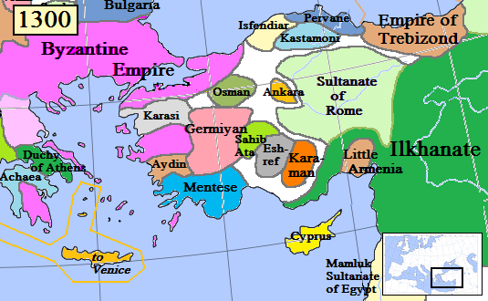
English: Map of the Anatolia region in AD 1300.
(Partially based on Euratlas map of Europe, 1300.) |
| Datum | |
| Fons | Opus proprium |
| Auctor | Gabagool |
| Other versions |
.png)
Potestas usoris
I, the copyright holder of this work, hereby publish it under the following license:
This file is licensed under the Creative Commons Attribution 3.0 Unported license.
- Tibi licet:
- communicare – copiare, distribuere et committere hoc opus
- to remix – to adapt the work
- His condicionibus:
- attributio – You must give appropriate credit, provide a link to the license, and indicate if changes were made. You may do so in any reasonable manner, but not in any way that suggests the licensor endorses you or your use.
Historia fasciculi
Presso die vel tempore fasciculum videbis, sicut tunc temporis apparuit.
| Dies/Tempus | Minutio | Dimensiones | Usor | Sententia | |
|---|---|---|---|---|---|
| recentissima | 16:46, 20 Ianuarii 2017 | | 535 × 330 (81 chiliocteti) | Cplakidas | fixing Dodecanese: Menteshe never controlled the offshore islands; they remained Byzantine until the Hospitallers or Genoese of Chios took them. |
| 22:26, 17 Aprilis 2009 |  | 535 × 330 (64 chiliocteti) | Gabagool | Byzantine color lighter. New Armenia -> Little Armenia | |
| 19:12, 2 Aprilis 2009 |  | 535 × 330 (64 chiliocteti) | Gabagool | added mamluks | |
| 16:36, 31 Martii 2009 |  | 535 × 330 (63 chiliocteti) | Gabagool | {{Information |Description={{en|1=Map of the Anatolia region in AD 1300. (Partially based on Euratlas map of Europe, 1300.)}} |Source=Own work by uploader |Author=Gabagool |Date=2009-03-31 |Permission= |other_versions= }} <!--{{ImageUp |
Nexus ad fasciculum
Usus fasciculi per inceptus Vicimediorum
Quae incepta Vici fasciculo utuntur:
- Usus in als.wikipedia.org
- Usus in ar.wikipedia.org
- Usus in arz.wikipedia.org
- Usus in azb.wikipedia.org
- Usus in ba.wikipedia.org
- Usus in bg.wikipedia.org
- Usus in bn.wikipedia.org
- Usus in ca.wikipedia.org
- Usus in cs.wikipedia.org
- Usus in de.wikipedia.org
- Usus in el.wikipedia.org
- Usus in en.wikipedia.org
View more global usage of this file.