Fasciculus:African continent-la.svg

Size of this PNG preview of this SVG file: 635 × 600 elementa imaginalia. Aliae mensurae: 254 × 240 elementa imaginalia | 508 × 480 elementa imaginalia | 813 × 768 elementa imaginalia | 1 084 × 1 024 elementa imaginalia | 2 169 × 2 048 elementa imaginalia | 1 525 × 1 440 elementa imaginalia.
Sua resolutio (fasciculus SVG, nominale 1 525 × 1 440 elementa imaginalia, magnitudo fasciculi: 741 chiliocteti)
| Descriptio |
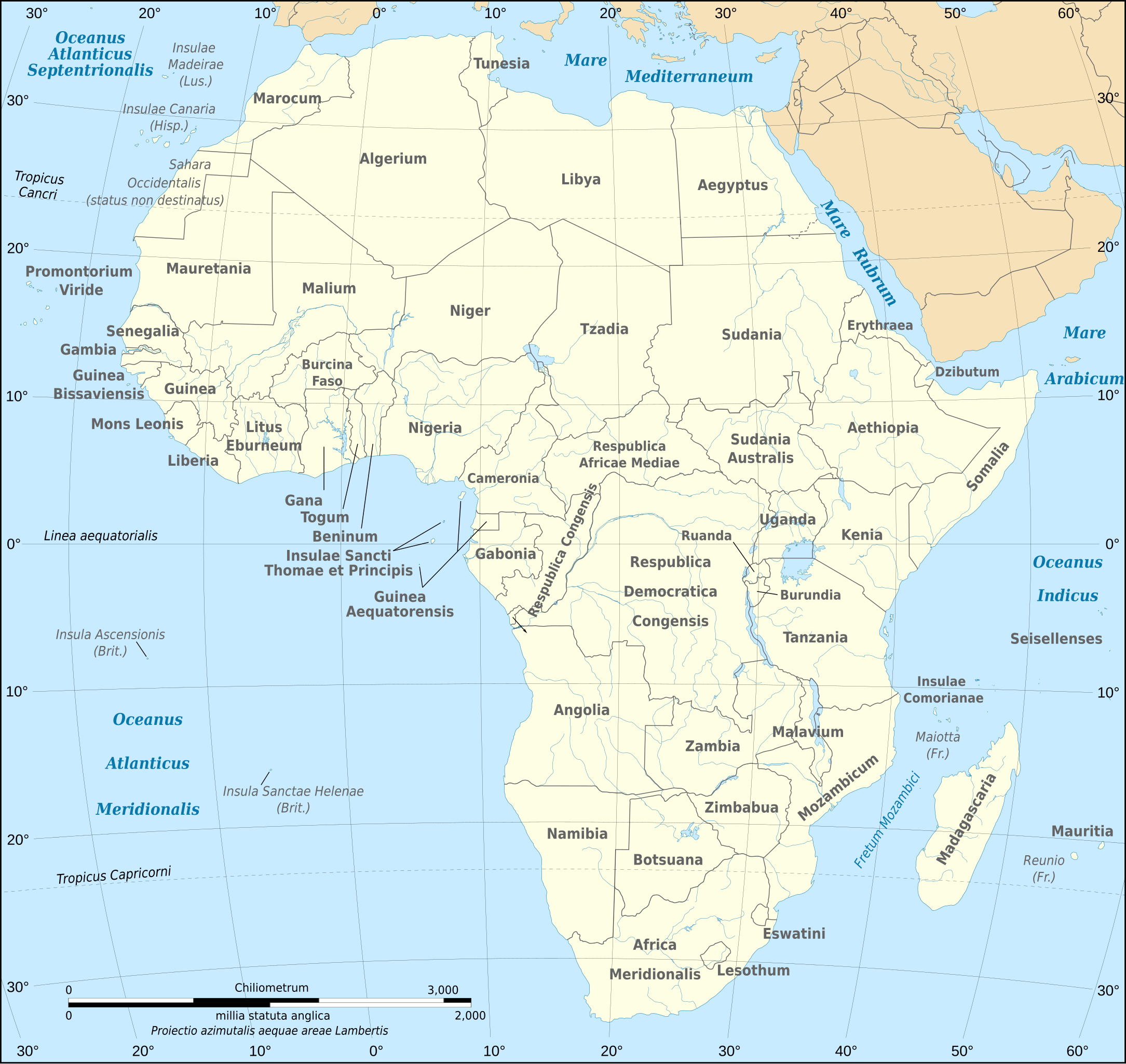
Latina: Tabula geographica Latine continentis Africae (07/2011) Français : Carte politique du continent africain telle qu'en 07/2011 avec légende en latin. English: Political map, translated into Latin, of the continent of Africa as of July 2011 (07/2011) Lambert azimutal equal-area projection, WGS84 datum, standard meridian: 15°E, standard parallel: 0°Scale: 1:15,000,000 (accuracy: 3,75 km) |
| Datum | (UTC) |
| Fons | |
| Auctor |
|
| Other versions |
[]
|


| This is a retouched picture, which means that it has been digitally altered from its original version. Modifications: Latin translation. The original can be viewed here: African continent-fr.svg:
|
I, the copyright holder of this work, hereby publish it under the following licenses:
This file is licensed under the Creative Commons Attribution-Share Alike 2.5 Generic, 2.0 Generic and 1.0 Generic license.
- Tibi licet:
- communicare – copiare, distribuere et committere hoc opus
- to remix – to adapt the work
- His condicionibus:
- attributio – You must give appropriate credit, provide a link to the license, and indicate if changes were made. You may do so in any reasonable manner, but not in any way that suggests the licensor endorses you or your use.
- aequa parte – If you remix, transform, or build upon the material, you must distribute your contributions under the same or compatible license as the original.
| This file is licensed under the Creative Commons Attribution-Share Alike 3.0 Unported license. | ||
| ||
| This licensing tag was added to this file as part of the GFDL licensing update. |

|
Licet hoc documentum exscribere vel distribuere vel demutare sub GNU Liberarum Litterarum Licentiae conditionibus in editione 1.2 aut in ulla editione recentiori a Fundatione Liberarum Programmationis Partium publicata; praeterquam Sectiones Immutabiles et Verba Involucra Adversa et Aversa. Licentiae exemplar praesto est in sectione intitulata GNU Free Documentation License. |
Tibi typum permissionis ligere licet.
Original upload log
This image is a derivative work of the following images:
- File:African_continent-fr.svg licensed with Cc-by-sa-2.5,2.0,1.0, Cc-by-sa-3.0-migrated, GFDL
- 2011-07-14T19:39:55Z Sting 1525x1440 (757418 Bytes) Sudan/South Sudan 2011-07 border update
- 2009-03-12T21:28:38Z Sting 1525x1440 (773348 Bytes) Correction Sao Tome (again) ; all fonts in DejaVu condensed
- 2009-01-10T19:52:08Z Sting 1525x1440 (766974 Bytes) Correction Sao Tome
- 2008-06-27T21:24:01Z Sting 1525x1440 (768579 Bytes) "Rép. du Congo" name correction
- 2008-06-27T01:46:54Z Sting 1525x1440 (768455 Bytes) One name correction
- 2008-06-26T23:37:59Z Sting 1525x1440 (768465 Bytes) Completely new drawing with known projection ; new colors
- 2006-05-31T22:56:10Z Sting 1390x1295 (626331 Bytes) {{Information |Description=Political map of the [[:Category:Maps of Africa|African continent]] with French caption |Source=Several bitmap-type maps |Date= May 2006 |Author= Eric Gaba ([[User:Sting|Sting]]) |Permission=GFDL or
Uploaded with derivativeFX
Historia fasciculi
Presso die vel tempore fasciculum videbis, sicut tunc temporis apparuit.
| Dies/Tempus | Minutio | Dimensiones | Usor | Sententia | |
|---|---|---|---|---|---|
| recentissima | 18:44, 6 Decembris 2020 | | 1 525 × 1 440 (741 chiliocteti) | Sting | Swaziland => Eswatini |
| 18:09, 28 Septembris 2011 |  | 1 525 × 1 440 (741 chiliocteti) | Amphipolis | {{Information |Description={{la|Tabula geographica Latine continentis Africae (07/2011)}} {{fr|Carte politique du continent africain telle qu'en 07/2011 avec légende en latin.}} Lambert azimutal e |
Nexus ad fasciculum
Ad hunc fasciculum nectit: