Fasciculus:Map of Hven from copper etching of Blaeu Atlas 1663.jpg
Sua resolutio (6 304 × 4 939 elementa imaginalia, magnitudo fasciculi: 19.49 megaocteti, typus MIME: image/jpeg)
| Descriptio |
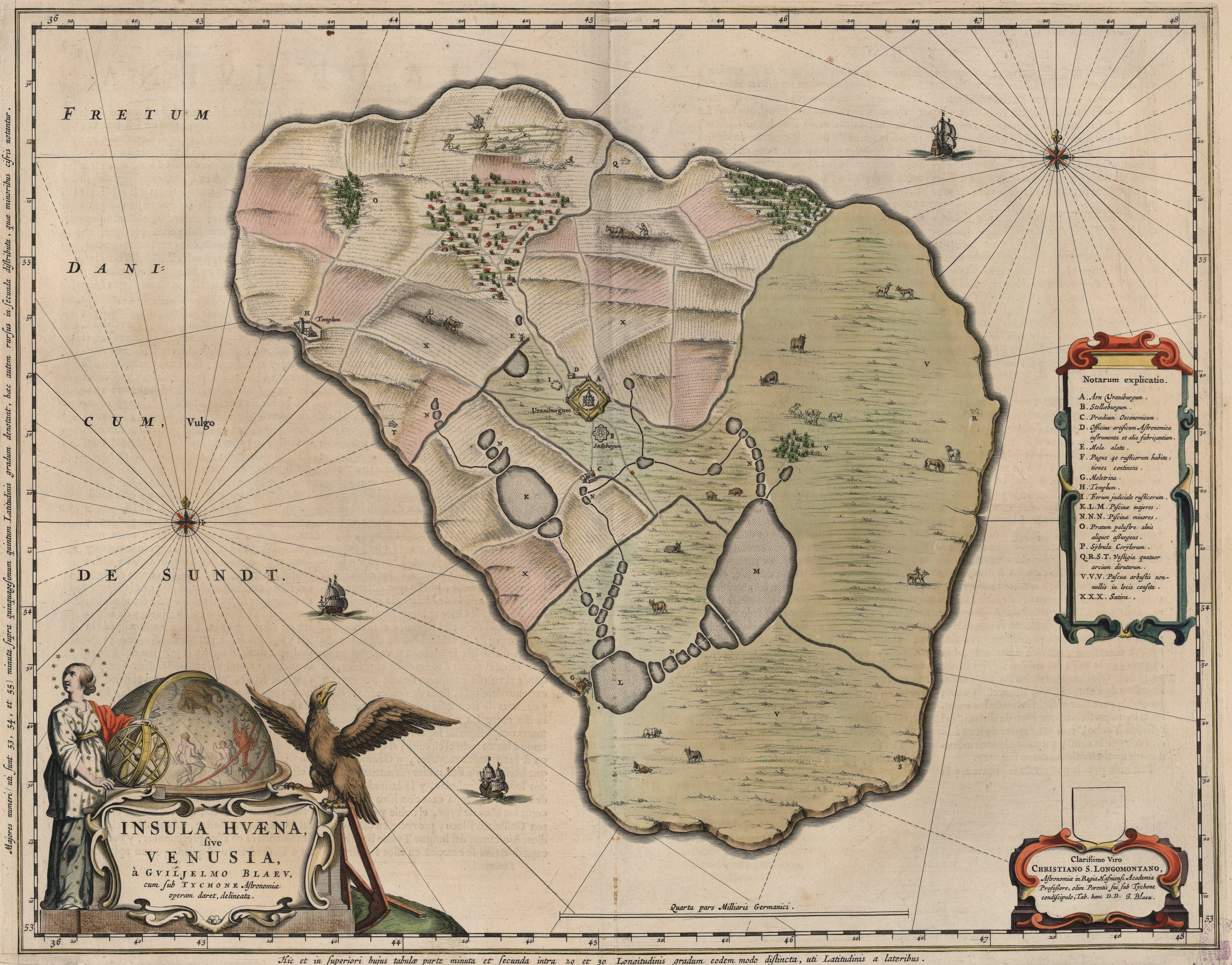
English: Map of the island of Hven from a copper etching of Willem Janszoon Blaeu's Blaeu Atlas 1663.
Willem made this map based on his experience as a student of Tycho Brahe between 1594 and 1596. On this map North is up, Denmark to the west and Scania, now part of Sweden, to the east. It shows the location of Uraniborg just above the centre, and below the linked set of ponds that Tycho had created to both collect water and power his papermill and other small industries on the island. Name of map : INSULAE HVAENA Map record source: Biblioteca Nacionale Espana (click on "View Digital object" to browse from the first page down to "GMG/189/177/mapa") (1664 is date of atlas on title page at "GMG/189/5/hg-ilustracionr") vorige upload: Tychobrahe.com
|
||||||||||||||||||||||||||
| Datum | |||||||||||||||||||||||||||
| Fons | (There is no permanent link) Browse to [1], click "View Digital Object", scroll down and click on link "GMG/189/177/mapa", image should appear named "GMG189177mapa.jpeg" in right hand panel. | ||||||||||||||||||||||||||
| Auctor |
|
||||||||||||||||||||||||||
.jpg)
|
This work is in the public domain in its country of origin and other countries and areas where the copyright term is the author's life plus 100 years or fewer. | |
| This file has been identified as being free of known restrictions under copyright law, including all related and neighboring rights. | |
| Annotations | This image is annotated: View the annotations at Commons |


Historia fasciculi
Presso die vel tempore fasciculum videbis, sicut tunc temporis apparuit.
| Dies/Tempus | Minutio | Dimensiones | Usor | Sententia | |
|---|---|---|---|---|---|
| recentissima | 01:06, 9 Augusti 2016 | | 6 304 × 4 939 (19.49 megaocteti) | Centpacrr | crp |
| 11:46, 4 Ianuarii 2013 |  | 7 598 × 6 341 (5.28 megaocteti) | Joop Rotte | ietwat hogere resolutie | |
| 18:18, 30 Decembris 2005 |  | 750 × 601 (89 chiliocteti) | Fred J | :: '' Originally uploaded on English Wikipedia by en:User:Wikibob. Map of the island of Hven from a copper etching of Willem Janszoon Blaeu's Blaeu Atlas 1663. Willem made this map while a student of Tycho Brahe between 1594 and 1596. On th |
Nexus ad fasciculum
Ad hunc fasciculum nectit:
Usus fasciculi per inceptus Vicimediorum
Quae incepta Vici fasciculo utuntur:
- Usus in de.wikipedia.org
- Usus in en.wikipedia.org
- Usus in et.wikipedia.org
- Usus in fa.wikipedia.org
- Usus in fr.wikipedia.org
- Usus in ia.wikipedia.org
- Usus in ja.wikipedia.org
- Usus in ko.wikipedia.org
- Usus in mk.wikipedia.org
- Usus in nl.wikipedia.org
- Usus in pl.wikipedia.org
- Usus in ru.wikipedia.org
- Usus in sv.wikipedia.org
- Usus in uk.wikipedia.org
- Usus in zh.wikipedia.org